A couple months ago, while searching for Dutch kayaking info, I discovered
Johan's Kano Route website, which describes kayaking routes in the Netherlands and a few in other countries. I clicked around for the routes within biking distance of Delft, and there are quite a few. He always lists the nearest kayak rental shops, which is helpful for a car-less boat-less person like me. Elizabeth and I decided to embark on the
Rotterdam route (which only takes you to the center of Rotterdam if you paddle > 16 miles).
 |
| Greenhouses, canals, and bike paths. So far, that sums up the suburban scenery within biking distance of Delft. |
Early Sunday morning we departed the sleepy streets of Delft and biked east, towards Berkel en Rodenrijs - a small town approximately half way to our destination. We were sorely disappointed when every single business was still closed, even the coffee shops, at 9am. The scenery gradually transitioned to more agricultural, and around 10am we arrived at the Rottemeren ("lakes of the Rotte river"), where we rented two little kayaks from
Botenverhuur Van Vliet. While we were happy with the affordable rentals (€5/hour or €25/day), we were a bit miffed to hear that PFD rentals were at additional cost, especially when we were given extra large PFDs that contained very little flotation material. I suppose kayaking on highly regulated canals is a bit safer than other settings, but still! The boats were a small step up from the whitewater boats that
Stijn, Bridget, and I rented in Ghent a few weeks earlier.
 |
| Along the canals you find rowing clubs every few miles! |
The rental shop is on the west side of the Rotte River, the namesake of nearby Rotterdam. The river is constrained on either side by high levees - the surrounding areas lie well below sea level. We were surprised by the narrow freeboard (vertical space between water level and top of levee) along much of the river. This may be due to the small watershed area of the Rotte - it originates just a few kilometers north of where we started kayaking.
Historically, the Rotte River drained the Zuidplas Lake, before it was turned into the Zuidplaspolder in 1840. A polder is a low-lying area that used to be marsh/wetland/water and was drained and diked by humans for development. At 7m (24 ft) below sea level, the Zuidplaspolder is tied with the Lammefjorden in Denmark for the lowest ("dry") point in Western Europe. I wish I'd known this before our trip!
 |
| Thousands of fundraising bikers passing the Cafe Oud Verlaat |
Dark clouds released a 10 minute rainstorm while we changed into our kayaking outfits. Luckily, 5 minutes into the trip the rain stopped and didn't bother us again all day. The first portion of the route goes through the Rottemeren, where the Rotte widens into a gusty lake where sailing is popular. Soon, the river narrowed again. Our motivation level was at a bit of a low, so we landed on the dock at Cafe Oud Verlaat (see photo above) and paused for some hot drinks and typical Dutch apple cake. The cafe was packed with Sunday morning biker groups, who were having the same fare.
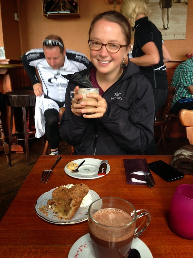 |
| So happy to have found coffee and apple cake, 2 miles into our paddle :) |
 |
| Filled with apple cake energy |
Back on the water a half hour later, we were revived and excited to continue on our journey. We passed an artificial ski hill, where people seemed to be skiing and snowboarding (no snow, mind you). At this point the river became more developed, and we had a chance to see into the lives of many canal side families enjoying a relaxed Sunday brunch (no one closes their curtains here).
 |
| Massive canal houses |
 |
| Can't forget the windmill photo |
Crew shells and many large boats sped past us, and we joked about hitching a ride on the way back (well, it was serious until it came down to putting our thumbs out - then my shyness overtook the situation!). We often caught up to the large boats at low bridges, which we zipped under while the larger boats waited for the scheduled bridge openings.
We paddled until ~1pm, when we looked at the map and realized that downtown Rotterdam and the Kralingse Plas (two potential destinations) were still many kilometers away. Instead, we aimed for the Bergse Voorplas, a lake on the right side of the river. The map showed a narrow blue strip connecting the river to the south end of the lake. To our disappointment (or maybe relief?), the narrow canal was actually a manually-operated lock connecting the high river to the low lake. Instead, we unloaded at a small dock and walked across the levee to the lake with our afternoon veggie snacks. The lake was incredibly windy, so we turned around after a short walk to the marina, where a sailing race was beginning. We watched a small motor boat passing through the lock, which was manually operated by a woman sitting in the adjacent booth.
 |
| Views across the Bergse Voorplas (small lake with many sailboats) |
Not too much happened on the return trip, except a gradual draining of our energy levels and increase in wind. We paid for our kayak rentals and made it 0.5 km down the bike path before veering into a lakeside cafe, where we feasted on tomato soup, french fries, croquet (fried gravy stick), and two massive bottles of water, which I promptly poured into my nalgene bottle (much to the server's amusement).
 |
| Typical canal scenery |
We took a more scenic and slightly longer bike route back to Delft, consisting of mostly independent bike paths (no adjacent street). At ~7pm we arrived home and I promptly fell asleep before I could even taste the delicious deviled eggs that Elizabeth made for dinner.
Date: Sunday, Sep 21st, 2014
Distance: 12.2 miles (19.6 km) kayaking + 24 miles (39 km) of biking
Duration: 6 hrs kayaking + 2.5 hrs biking (includes 2 cafe stops!)
