You're currently viewing the old version of this site.
Please visit www.nakedkayaker.com for recent posts and better maps, etc.!
Showing posts with label sand dunes. Show all posts

23 August 2014

De Zandmotor, Herring, and the Girl with the Pearl Earring

Last Wednesday was a day of all-things-Dutch. Again, no kayaking. But there is kayaking on the horizon, so stay tuned!

8am arrival in Den Hague, the next big city north of Delft and the official seat of government in the Netherlands (but not the capitol - that's Amsterdam). I obtained my official residence and work permit documents before we commenced the day's fun. We hopped on bus #24 towards Kijkduin (which literally means "Look Dune") - a small coastal town which seemed to be driven primarily by beach tourism. We hid in a postcard shop from a brief rain shower, during which Bridget purchased a variety of slightly inappropriate postcards: friends of Bridget: watch out.

Downtown Den Hague
We then began walking along the beach boardwalk toward the Zandmotor (known in English as the Sand Engine), an incredibly wide beach that protrudes from the adjacent shorelines. This was constructed in 2011 by placing a massive amount of sand along this 2 km stretch of coast. While beaches are often "nourished" by placing sand to widen the beach, this is unsual in the shear volume of sand that was placed. The beach erodes over time as breaking waves push sand downstream, widening beaches further down the coast. The idea was to place a lot of sand instantaneously and infrequently rather than more typical annual/frequent beach nourishment schemes, which have pretty big impacts on the dune, beach, and subtidal ecosystems. The Dutch believe this is better for the ecology and environmental impacts, and it's a pretty creative idea. You also don't have to manually place sand on all the beaches downstream since the sand eroded from this extra-wide beach will keep those wider. Since this is really the first of it's kind, there are extensive monitoring programs in place, with wave buoys, camera systems, and survey crews. I almost accepted a PhD position to study the waves and rip currents around this nourishment a couple years ago, so I was excited to visit it soon after arriving!

Map of our 5 mile walk around the Zandmotor. You can see how much wider the beach is at this location. There are two lagoon-ish ponded areas in the back of the dune, which apparently serve some function to protect groundwater quality, which isn't entirely clear to me...
The entire beach was strewn with small shells. I'm not sure whether these came with the sand that was placed on the beach (most likely?) or whether they were deposited there later on.

There were researchers out this morning measuring something in the surf zone.
The Argusmast. This tower holds multiple cameras, which are used for monitoring waves, shoreline erosion, number of beach visitors, and even for predicting where rip currents might occur, to keep swimmers safe.


Side view of the sand engine
When we returned to Den Hague, we tried out the local fare: raw herring fillet on white roll, smothered in onions. Never has anything smelled so fishy. Can't really endorse this one with much enthusiasm, though we did finish the entire sandwich.

Fast forward, and we're back in Delft for the evening. We've seen advertisements all around the city for $15 Girl with the Pearl Earring portraits (the painting by Vermeer, who lived in Delft). Bridget, Elizabeth, and I decided that we could do this ourselves, so with the help of some white wine, we managed to pull together this portrait in ~15 minutes. Thanks to Elizabeth for setting the black background *sheet*, Bridget for being an excellent photographer who held the camera still between excessive giggling, and both of you for getting that ridiculous head wrap to stay on my head :)

21 August 2014

Bike Touring on Texel Island

I'm in Delft! This post is not about kayaking...

Bridget spontaneously decided to come visit for 2 weeks after her work cruise in Romania was cancelled. The Netherlands is close to Romania, right? She arrived a day after me and we've been exploring the city of Delft together. Of course, our first inclination was to get out of the city, so we made plans to visit Texel Island, which is one in a string of barrier islands (the Frisian Islands) along the Netherlands, Germany, and Denmark. The map below shows the West Frisian Islands, along the Dutch coast. Texel island is the furthest west, and connects to the mainland (city of Den Helder) by ferry.


From the Delft train station (~1 mile from my apartment), we took two trains to reach Den Helder. From there, we wandered along the levee in Den Helder until we found the ferry terminal (vaarhaven).

The levee/seawall along the coast in Den Helder. No beach left here...
Almost at the ferry terminal
Texel Island is best seen by bike, so we rented bikes next to the ferry terminal when we arrived. We rented the cheap bikes (no gears) for 12 euros/person for 2 days. It took some finagling to attach my backpack to the back of the bike. This was my first overnight bike trip, so it was all new to me. Bridget informed me that this was NOT how bike gear is normally organized. We rode 12 km to Den Koog, which is on the northern coast of the island. On either side we were greeted with picturesque fields of sheep, cows, and horses.

Happy Bridget, moments before her backpack fell off the bike.
Massive backpack strapped to bike.
Baaaaa
The rest of the afternoon was a combination of (covered) patio drinks, window shopping, beach wandering, biking, and admiring the Dutch style of camping (Monster tents with wifi, front porches, fully equipped kitchens, and multiple rooms). We scouted out a lunch spot behind a beach bar which was in a wind shadow, only to have sand dumping on our heads and picnic from above. Mmmmm crunchy cheese. We spent a few hours huddling in the tent during the afternoon thunderstorms, after which we went on a much less gear-laden bike ride to the neighboring Dunes of Texel National Park and watched the sunset from the beach.

One example of a massive Dutch-style encampment
Hiding in our mini tent during one of many afternoon thunderstorms
Sunset walk at the Dunes of Texel National Park

The next morning we woke to a reasonably dry tent and a glint of sunlight. However, by the time we had packed up our bags, the rain was pummeling the tent once again. We conducted the worlds fastest tent take-down and ate our last bread and cheese in the campground bathrooms (less gross than you're imagining). We returned to our bikes and unlocked the super fancy Dutch locks (which lock across the spokes of the back wheel, simply preventing it from rotating. This allows you to leave the bike standing anywhere). On the trip back to the ferry terminal we encountered a massive deluge of rain and hail. After a few minutes of the intensity, we took shelter behind a small shed, huddling next to a French couple. We saw some of our biking acquaintances (other bikers who passed/we passed intermittently) battling the storm and waved from our happy dry spot. Back at the ferry terminal we shared grins of mutual understanding: we survived the storm together.

Huddling behind a shed, hiding from the hail and torrential downpour.

05 August 2014

Day 18: Sleeping Bear Dunes National Lakeshore

The Legend of Sleeping Bear (courtesy of NPS)
Long ago, along the Wisconsin shoreline, a mother bear and her two cubs were driven into Lake Michigan by a raging forest fire. The bears swam for many hours, but eventually the cubs tired and lagged behind. Mother bear reached the shore and climbed to the top of a high bluff to watch and wait for her cubs. Too tired to continue, the cubs drowned within sight of the shore. The Great Spirit Manitou created two islands to mark the spot where the cubs disappeared and then created a solitary dune to represent the faithful mother bear. You can see the two islands in the zoomed out map below (we paddled along the blue lines - see zoomed in map further down in this post).

Our trip (blue line below "Sleeping Bear Dunes") and the two baby bear islands from the legend
The launch site: Village Park in Empire, MI
Today we kayaked along the shore near the sleeping bears. Jeff and I drove across the UP and down to Empire, MI in 5 hours this morning, where we met up with Elizabeth (my future roomie in Delft, who I'd never met before!) and her sister Ali. Jeff and I successfully jammed up the parking lot waiting for a spot to free up, but the car was parked things went smoothly. Parking was ~$1/hr. Sleeping Bear Surf and Kayak delivered 3 kayaks to the Village Park beach from their shop a few blocks away. The wind was whipping up some small, choppy waves on Lake Michigan, but we launched successfully (with an intentional refreshing dip by Elizabeth and Ali before departing). 

Elizabeth (front) and her sister Ali (back) paddling into the wind
Elizabeth and I chatted about Delft and "quitting" our jobs (Elizabeth is also going to work part time remotely) as we paddled into the wind. Along the shore the beaches were very narrow, with an actively eroding scarp (I was later informed that water levels in the Great Lakes are very high this year due to the extremely stormy/snowy winter). 

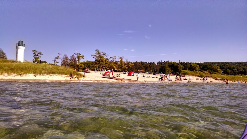
Our first stop was North Bar Lake, a small freshwater lake attached to Lake Michigan through a shallow channel. We dragged our kayaks over the low sandbar at the mouth of the lake and weaved through swimming children, trying not to be pelted by the various beach-related toys flying through the air. The water in the small lake was significantly warmer than in Lake Michigan. 

Arriving at the entrance to North Bar Lake. The water was so clear!
The crowded inlet channel to North Bar Lake
We continued up to the southern tip of the Sleeping Bear Dunes to have a brief photo shoot. We watched tiny tourists running/rolling down the 400-ft dune in the distance and wondered how they would ever get back up. The return trip was significantly easier/speedier thanks to the tailwinds pushing us along. 

Elizabeth and I doing the kayak-win-cheer!
Jeff and the gorgeous view of Empire Bluffs in the other direction
Date: August 5th, 2014
Distance: 7 miles
Duration: ~4 hrs

A zoomed-in version that shows the launch site (Village Park in Empire), our stop at North Bar Lake, and the bottom tip of the huge sand dunes.
The Non-Kayaking Portion: After our paddle, Elizabeth gave us all a ride in her convertible (first time, woo!) to Glen Arbor where we visited Cherry Republic. Elizabeth rightfully called this a "campus," as there are three buildings dedicated to cherries: snacks (free samples galore), drinks (cherry wine and hard cider), and ice cream. Our stomachs full of cherries and cheez-its (we'd snacked on these in the car), we returned to Elizabeth/Ali's home in Traverse City. Together with their parents, they cooked up a delicious dinner (BBQ chicken, pasta salad, caprese salad, and mango salsa), which we shared on their back patio with various pink drinks. We were informed that there was a skunk stuck to a fence somewhere on the property and that a snack had been spotted earlier, but otherwise the garden was beautiful and peaceful. We spent a great deal of time examining each other's kayaking tans/burns (it was super sunny today). A few showers later, we chatted about all things Dutch. In particular, we stalked our future Delft friends on Facebook, discussed gravy sticks that come out of vending machines, and mapped out a plan to bike/ferry to London. I can't wait to move to the Netherlands!

First convertible ride ever. Headbands are essential in the windy back seat!

04 August 2014

Day 17: Pictured Rocks National Lakeshore (no kayaking...)

Last night we crossed the Eastern/Central time zone and realized it was much later expected, so we pulled over and camped in the Squirrel Rapids Picnic Area, halfway between the Apostle Islands (WI) and Pictured Rocks National Lakeshore (MI). We were up early to the sound of lawn mowing all around us. After a quick stop at a farmstand for veggies and breakfast, we drove across much of Michigan's Upper Peninsula (the UP) on Route 28. 

At Pictured Rocks we attempted to find a campsite at the Twelvemile Beach Campground (I'm pretty sure this is where Marika and I stayed 3 years ago), but all the sites were full (on a Monday!). Instead, we headed a bit further east to the Upper Hurricane River campground and snagged a big site where we cooked up an extravagant veggie-full burrito lunch. 

Our site at Upper Hurricane River campground
Food coma overtook us and I sprawled out on the beach for an hour while Jeff went exploring (food comas affect us all in different ways). One lesson I've learned on this trip is that I am no longer capable of reading a novel. Goal #10 for my year of sabbatical: manage to finish reading a novel without falling asleep.
 
Excited about clean hair
We decided to stop being beach-bums and drive to Grand Marais, passing Grand Sable Lake on the way. West Side Diner had immediate ice cream potential. Immediate sensory overload overcame us upon entering the diner. Shelves of steaming baked goods were interspersed with quality touristy trinkets. The diner was busy, so we sat at the counter in the diner car before eventually ordering (1) apple crumble with vanilla ice cream, (2) cinnamon roll with cream cheese frosting, (3) chocolate ice cream. Yes, we were craving sugar. Day 16 was clearly lacking in calories, because sugary things were on our minds all day. 

Sucker River Lagoon outlet
Feeling slightly sick, we decided to get some exercise. First, we drove to Sucker River Lagoon, at the end of a long residential road, and went for a brief beach walk. We had to hop over a few Private Property signs to reach the beach. Next, we hiked to Sable Falls and the adjacent beach (very easy hike down massive new staircase) before walking the Grand Sable Dunes trail and taking silly shadow photos from the top of the massive dunes. The dunes here are made of incredibly fine orange-reddish sand.

Grand Sable Falls
Dune slide at the end of the Grand Sable Falls trail

We then made another U-turn to Grand Marais to have a beer and people-watch at the Lake Superior Brewing Company. We impulsively decided to visit the Log Slide – the essence of which eluded us. A brief walk through the woods brought us to a massive steep sandy cliff where logs used to be slid down a wooden chute to the lake. Rumor has it that the chute was so long that extensive friction caused it to catch fire. To the east were massive untouched sand dunes basking in the warm evening sun. Signs everywhere warned of dune collapse that buried and suffocated previous visitors. It said “it takes 5 minutes to get down and over an hour to get back up.” Needless to say, we did not go down.

View of massive dunes from the Log Slide Outlook
Now we’re back at camp – I chopped veggies for a breakfast stir-fry and Jeff made a campfire that we are now enjoying. We are a little sad that we did not sea kayak here, but the rental shops were expensive and far away. Kayaking on Lake Michigan tomorrow!

20 May 2014

Midwest Reunion Road Trip to Morro Bay

In September 2008, Nena and Terry met and moved into a little apartment in Cincinnati, Ohio, where Terry taught Nena how to dance like Justin Timberlake and Nena taught Terry how to recycle (ok, so both of those lessons failed). However, some of the cross-cultural exchanges stuck. For example, Terry developed an affinity for hiking and country music that grew long after the end of the Procter & Gamble internships. In May 2014, Terry visited Nena in California with one request: go on a California adventure.

Commence road trip to Morro Bay, in the first person.

At 6am on Friday morning we departed Berkeley after a much-needed but too-short night of sleep. We beelined down HWYs 880/101/1 until we arrived in exotic Carmel, just in time for a hearty breakfast burrito. We were chatted up by surf-instructor Ed, who nearly convinced us to stick around for surf lessons. After some beach frolicking we continued down scenic HWY 1 along the coast - a stretch of coast that I'm less familiar with. The views were staggering!


We stumbled across some beaches drenched in sea lions, where we gleefully watched them grunt, grown, and throw sand on each other for a half hour.


After some mishaps (1. Nearly running out of gas, then paying $6/gallon, 2. Stopping by Hearst Castle and being severely disappointed - you have to pay $25 just to get near it!) we arrived in Morro Bay, set up camp, went for a short hike to look at the bay, ate a delicious lunch at a vegan/vegetarian restaurant (much to Terry's surprise), and went for a hike in Montana de Oro State Park, just south of Morro Bay.

Views from our hike in Montana de Oro State Park
After surviving the hike without a mountain lion attack, we returned to Morro Bay (the town) and went to the windy beach. We observed a ship practicing turns at the mouth of the harbor for a little while before heading into town for some fish & chips and white wine: classy!

Morro Bay is famous for Morro Rock, which defines the skyline of the Bay (Morro = spanish/portuguese/italian for prominent rock formation). The rock used to be surrounded by water, but was connected to land by the U.S. Army Corps of Engineers to construct Morro Bay Harbor. The rock was quarried for 80 years before being preserved for peregrine falcon habitat. A large power plant, characterized by three tall cooling towers, sits adjacent to the harbor.

Dynegy power plant (a.k.a. "Three Fingers")

We camped out at Morro Bay State Park (only moving campsites once to avoid sleeping next to a Rihanna party and nearly being ticketed the next morning for moving into the wrong campsite). On Saturday morning we arrived at Kayak Horizons just in time for the 10% off deal (arrive before 10 am). I had to launch my boat at Anchor Street Park, a few blocks south. 

5 minute kayak training for Terry
Once Terry was settled into her rental boat, we followed a tip to cross the Bay and look for narrow points in the sand spit, where we could extract ourselves from our boats and hike over the dunes to the ocean-side beach. Apparently we don't know how to follow directions, because we found ourselves in shallower-and-shallower water, eventually bottoming out and having to backtrack. We never did find the trails, but we did get to look at the sand dunes up close.


We meandered down the Bay and then back up towards the harbor to look for seals and otters. Some paddle boarders broke the sad news that otters seemed to be lacking in all their usual hang-out spots, so we begrudgingly accepted that sea lions would be the most exciting discovery:


5 miles later we were tired out and headed back to the rental shop. We departed Morro Bay, refilled on sunshine and salt water, and headed back to San Francisco with a quick stop for delicious Thai food in Paso Robles.

Thanks for visiting, Terry!! :)


Date: Saturday, May 10th, 2014
Time: ~2 hours
Distance: ~5 miles

05 April 2014

Moon Snails, Loons, Seals, Sea Stars, and Fish Heads: Tomales Bay Never Disappoints.

Starved of salt water and kayaks longer than 10 ft, Colorado Jeff flew to San Francisco for a weekend of bingeyaking (my second favorite verb, after sponyaking). The bingeyaking was certainly not spontaneous, as we spent two weeks planning our routes and finding ways to squeeze as many miles into one weekend as possible.

Friday evening logistical madness (read this in fast-forward):
(1) Nena picks up foam blocks at undisclosed location in Oakland.
(2) Nena picks up Jeff from train station.
(3) Nena and Jeff visit Doug to deliver unlucky (I had no idea) lava rock from Hawaii and pick up kayaking gear that Doug generously let Jeff borrow for the weekend. 
(4) Doug gives Nena and Jeff final clue in the pre-kayak-logistics-scavenger-hunt: address of missing sea kayak.
(5) Nena and Jeff drive across Oakland to sketchily retrieve Orange Crush at other undisclosed location.
(6) Nena and Jeff purchase fruits and veggies for the whole weekend. 
(7) Nena and Jeff have a quick dinner at purple-noodle-place (I can't remember the name) and soon return to the Glen House for a brief night's sleep.
(8) Nena wakes up and makes homemade hummus. (Or did that happen at night? it's a blur)

Jeff and I packing up the car in rainy Berkeley on Saturday morning.
Okay that's enough of the 3rd person. We had planned to paddle Estero Americano (i.e. Americano Creek) from Valley Ford Road to its confluence at Bodega Bay. Unfortunately, the weather forecast was looking pprreeettyyy miserable for Saturday, with heavy rains guaranteeing that the mouth of the creek would be open (flowing directly into the ocean instead of ponding behind the beach). The tides and creek current would both be against us on the 6-mile return trip, and we worried we might never return. We reassessed on Saturday morning and ended up a bit further south, on Tomales Bay. 

Nick's Cove. Photo taken from the launch dock. $5 Parking

We arrived at Nick's Cove around 11am on Saturday morning (a leisurely start, to let the rain pass by). While it wasn't raining, the sky was grey and we had the launch site completely to ourselves. Nick's Cove is a remote little tourist destination with a restaurant serving locally-caught fish and cottages right on the water. The whole places is owned by one person, but the boat launch is public.  I've paddled on Tomales a couple times, but always starting from points much further south, so I was excited to check out the north end of the Bay. We paid $5 for parking, launched from the well-kept dock, and headed north. We hugged the east shore and explored the little bays and inlets as we made our way towards the mouth of Tomales Bay. Along the way we found some treasures, like this massive, perfectly-severed fish head. 10 points for the person who can tell me what kind of fish this is!

Monster fish head on the beach. No eyeballs left.
As we rounded Tom's Point, we encountered some beautiful windswept sand dunes. We spent a while between Tom's Point and Sand Point to take pictures of dunes and loons and seals and tule elk (er... cows):

Fuzzy sand dune

Huge sand dunes near Lawson's Landing

A loon! We were surprised to see one in the salt water.
Seals glaring.
Jeff saying "Hi Seals! Happy you're not sharks!"
Nena saying "Hi Cows! Sad you're not Tule Elk!"
We finally peeled ourselves away from the mammals and birds and paddled up to Sand Point, which marks one of the narrowest parts of Tomales Bay. The tide was going out rapidly, and we found ourselves riding the tide towards the mouth of the Bay (and the Pacific Ocean). Ocean waves propagate into the Bay, and with the ebbing tide this made for some tumultuous conditions. The tide was trying to escape and the waves were trying to enter, leaving churning/confused standing waves. We were later informed that this is prime breeding ground for great white sharks. Jeff went and played in the waves while I swiftly crossed the bay and searched for a lunch spot.

Jeff playing in the standing waves at the mouth of Tomales Bay
We realized the tide was ebbing at the same speed we were paddling, so after ~20 minutes of a kayak treadmill workout we decided to pull over for lunch and wait for the current to slow. While snacking on hummus, pita, cucumber, tomatoes, carrots, and fruit, we watched fisherman zip back and forth in little motorboats, emptying traps filled with massive crabs and other critters. Eventually, we returned to the tide treadmill and made it to a wider part of the bay, where the currents slowed. Here we took a few minutes to star gaze:

Red star fish! We also saw sea urchins and anemones.
We stopped briefly to look at these marvelous white cliffs, which offer many caves for exploring during low tide.


Jeff in cave
We stopped at Hog Island (also described in this awesome trip) in the middle of the Bay. One side of the island was carpeted with sea lions, so we gave them some space and instead found some MASSIVE snails, also known as Moon Snails. These snails are predatory, attacking most other shelled mollusks, including fellow moon snails! They envelope their prey and then bore through the shell, sucking out the insides. If I had known this before, I probably would not have put it on Big Purple... This one glommed right onto my boat:

Moon snail!
When we returned to Nick's Cove, we walked to a little shack at the end of the wharf. Smoke curled out of the chimney from a wood stove inside. The shack was humble (I guess most are...), with one large wooden table and some nautical decorations. The phone on the wall is used to order take-out from the restaurant onshore. I'll be back!


Date: April 29, 2014
Time: ~4.5 hours?
Distance: 11 miles