Last weekend Alice and I made an expedited road trip up towards Redding to dip our paddles in freshwater for a change. She'll be writing a post about our first day of paddling on Lewiston Lake, so stay tuned (Alice is a teacher and tomorrow is her last day of school!). Around 6:45am on Memorial Day we departed our lovely hill-side campsite at Lewiston Lake and headed back towards Whiskeytown Lake, stopping only for coffee/CheezIts/Ritz crackers at a gas station (surprisingly open at 7am on a holiday). Alice humored me as I cranked up the Whiskeytown (a country band that I discovered during my Friday Night Lights phase, and the real reason I wanted to go on this paddle). We launched from a little scarp adjacent to Oak Bottom Marina around 8:30am and began a relaxing morning paddle.
 |
| Launching at Oak Bottom Marina |
We tried to find Oak Bottom Ditch Trail (the long narrow channel extending from the NW corner of the lake -- see map below), but we must have overshot and ended up in one of the gullies just south of it. It's hard to find your way on these lakes, where everything looks similar and depth is hard to perceive. We continued along the west shore until we arrived at Brandy Creek, a picnic area/trailhead/recreational area where you can rent kayaks or hang out on a sandy beach. Alice landed on shore to enjoy some time on the beach. I carried on for another 45 minutes, determined to get a glimpse of the Clair A. Hill Whiskeytown Dam at the south end of the lake. I also identified an intriguing (but poorly named) feature on the map called the "Glory Hole," which was adjacent to the dam. I told Alice that I planned to investigate. Unfortunately I only had time to turn a corner and view the dam from afar, no glory hole in sight.
 |
| Gorgeous spring morning |
 |
| Alice rounding the bend. |
Upon returning to Brandy Creek, Alice informed me that she was very relieved to see me after having read some pamphlets about the lake and finding out what the glory hole was. Read on...
 |
| Tree on a rock! |
A little history & hydrology... Clear Creek was dammed in 1963 by the Bureau of Reclamation to create Whiskeytown Lake for flood management, water supply for irrigation, and electricity generation. The dam is earthen, which means that it should never be overtopped by water (or it can fail catastrophically). To prevent overtopping of the dam during big storms, the engineers had to include a way for water to drain from the reservoir at a high rate. In a
previous post I talked about an emergency spillway adjacent to an earthen dam on Virgil Creek in NY. In the case of Whiskeytown Lake, the spillway is a "Glory Hole" spillway (poorly named), which is essentially a tall drain that water can flow into once the reservoir gets too high. According to
this website, the spillway could drain an olympic sized pool in 4 seconds.
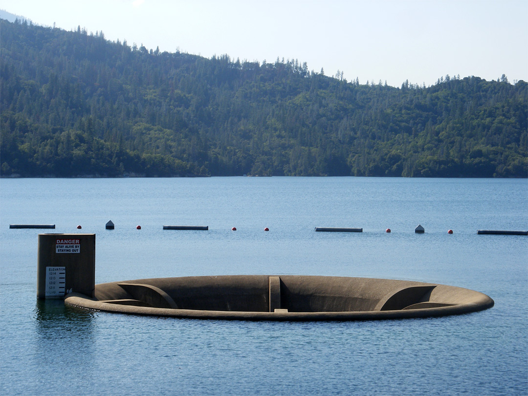 |
| Normal conditions |
 |
| Overflow conditions |
I'm happy to tell you that Big Purple and I did not get sucked into the glory hole, and I will never attempt to approach one again. Luckily the lake was not at flood stage, so the spillway looked more like the top picture!
Date: Monday, May 26th (Memorial Day)
Distance: 8.5 miles
Time: 3 hours

2 comments:
OMG Glory Hole can suck an entire Olympic sized pool in 4 seconds.. That's so scaryyyyyyyyyyy
Awesome histo lesson on Whiskeytown lake. I've never been up there but really want to - there's some epic mountain biking near there and I hear the water is eeriely clear.
Post a Comment