You're currently viewing the old version of this site.
Please visit www.nakedkayaker.com for recent posts and better maps, etc.!

20 July 2014

Day 2: Southern Oregon Coast

Sunday morning started early: I woke up around 5:50am after a reasonably sound night of sleep (having your own tent is a glorious thing), packed up the tent, and shared a sad goodbye with groggy Alice. The Mendocino coast road was foggy at 6:20am:


I drove for a few hours, until lack of coffee and gasoline led me to find the cheapest gas in the Eureka/Arcata area. Upon putting my visa card in the pump the machine returned a "Card Not Recognized" error, and I realized it was a gas station for truck drivers and other special people, myself not included. No wonder it was $0.20 cheaper. I reluctantly returned to a Chevron station and refilled on cheap coffee and expensive gas.

Since I'd spent a good amount of time in Humboldt/Crescent City/Smith River on past roadtrips, I booked it through the rest of northern CA with only a short stop at the Crescent City jetty/pier. The "Welcome to Oregon" sign came and passed, and I took a short break to hike down to Whalehead Beach.

Whalehead
I was a bit ahead of schedule, so I spent some time driving through Bandon and checking out the harbor.
Coquille River Harbor/mouth. Google turns my pictures into cool panoramas...
Breezing through Coos Bay, I met Bridget and her friend Stephanie in Winchester Bay at 3pm. Our meeting point was the Windy Bay Sourdough Bakery, where Bridget and I split a sourdough bagel and tasted all the mustard samples. mmmm. We looked at a map of Oregon Dunes National Recreation Area and selected the nearest trailhead: the Tahkenitch Dunes Trail. The complete loop, along the Threemile Lake Trail, the Tahkenich Dunes, and back along the Dunes trail is 6-miles.


The first leg of the trail meanders through the woods past some small lakes, with glimpses of the coastal dunes. In some locations a river of sand had come pouring down the hill, covering the trail:


The second leg of the hike was along the dunes, which made for much more difficult hiking. Since the dunes are constantly changing, the trail is less obvious. We found our way by connecting some tall wooden stakes placed strategically in some of the higher dunes. These dunes are interesting because they are fronted by a narrow forest - normally the sand dunes are directly along the ocean.


Just when we thought we couldn't take any more sand steps, the trail took a turn into the strip of trees along the beach, and we scurried down to the beach.

Tahkenitch Creek Lagoon


After ~45 minutes of recovering and snacking on the beach, we traced our footsteps to the trail intersection to return along the other side of the loop. A couple miles later we realized we'd taken the wrong fork in the trail, requiring an extra mile of "hiking" along HWY 101 to get back to the cars. The highway took us along Tahkenitch Lake, so while our joints were aching we managed to enjoy the extra leg of the hike. We maintained spirits by blasting country music from cell phones and doing ridiculous dances to extract honks from passing cars. Stephanie found a dead bird on the side of the road.

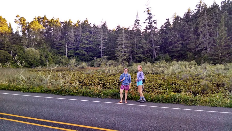

Upon our late return to the cars we commenced a massive spontaneous picnic of the usual pitas/veggies/hummus/fruit.  On the drive home we made a spontaneous decision (conducted through the car windows at a stoplight) to chase the sunset. We arrived at the coast seconds before the sunset:


19 July 2014

Day 1: The Big River and MacKerricher State Park

Alice and I followed each other up the 101 and west on the 128, stopping at a BBQ joint on the way to buy coffee and a mini bottle of champagne. Nena tailgated lots of people on the windy 128 with Alice close in tow. We stopped at the Paul M. Dimmick State Recreation Area to scout out a potential launch site on the Navarro River, but upon peering over the bank it was evident that we needed to go down river. There was very little water in the river at this point, and most of it was standing in small pools. Instead, we continued to the mouth of the Navarro River where we spent a half hour wandering around the beach. The lagoon was closed and filled with algae - a stark contrast to the flowing open lagoon that Lisa and I observed a couple months prior. We were able to access parts of the beach with natural arches that Lisa and I couldn't reach this spring:


We decided to continue on to the Big River in Mendocino and put in at the public beach just inland of the HWY 1 bridge.


We paddled up river with the incoming tide for over an hour, turning around when we realized we were not going to find a distinct landmark to map our route. We chatted about all the usual topics. The return felt long as we pushed against the wind and tide, but we played with kelp and watch a river otter munching on a snack. Alice found some curious bright blue giant barnacles. We stuck our noses into the pacific ocean for my last California coastal paddle.


After some rapid snacking on old tofu and veggies we continued up HWY 1 through Fort Bragg to get gas, ice, and water. When I asked the station attendant whether she sold oil, she asked me which grade and I said cooking grade.

At MacKerricher State Park we paid exorbitant camping fees ($43/night + $8 extra car fee!). We meandered along the beach boardwalk, attempting to take an attractive selfie and failing miserably. Alice: "that was really exceptionally bad."


We returned to camp, toasted our champagne, and cooked some veggies with pasta, making it to bed just after the planned bedtime... 


All in all, a very typical Nena-Alice kayaking/camping experience for our bon voyage adventure. I'm going to miss this girl!


Kayaking Stats
Date: 7/19/2014
Distance: 9 miles (guess)
Duration: 3 hrs


The Start of the Journey: Goodbye San Francisco Bay

Today marks the start of a 24-day cross-country road trip from San Francisco to Boston. I'll be heading up the west coast through Corvallis, Portland, Seattle, and the San Juan Islands before taking a turn and heading east through Bozeman, Bismarck, the Great Lakes, Rochester, NYC, and finally Boston. My hope is to post every couple days, which means my writing will be much more stream-of-consciousness. Apologies in advance for the typos and lack of research. I'm excited to share my experiences as they happen!


A quick recap: In March I found out I'd been awarded a Fulbright grant to study flood management in the Netherlands at the Technical University of Delft (TUDelft). I spent a few weeks hemming-and-hawing about whether or not to leave my great job as a coastal engineer in San Francisco and how to relay the news to my company. In April I broke the news, and the outcome was positive! They offered to let me continue working part time remotely during my year away.

Fast forward: much packing and selling and spreadsheeting later (I'll have to post my planning spreadsheet template at some point), I'm sitting in the Bed Bath and Beyond parking lot in Larkspur waiting for Alice to begin the first leg of this next adventure. Tonight we'll be staying at MacKerricher State Park on the coast in Mendocino County. We'll be kayaking on one of the nearby rivers today - location still to be determined.

The past couple weeks have been incredible. While saying goodbye every day is sad, it's been great to spend time with the amazing California friends I've gotten to know over the past 3 years. I'm already looking forward to my return to the west coast :)

Alice took some daring photos while driving...

09 July 2014

Independence Day on Richardson Bay

Hello Tennessee Valley, you beautiful dramatic landscape!


For 4th of July Alice and I decided to visit her favorite spot in Marin: Tennessee Valley. The hike takes you 1.8 miles from a parking lot through the lush valley to an open coast beach. Tennessee Cove lies between Muir Beach and Rodeo Beach - both of which we visited last year on a coastal paddle. Dark sand covers the narrow, steep beach at the end of the trail. Alice dodged crashing waves to run around a point and explore another narrow beach on the other side. Ten minutes later I began to wonder whether it was time to send out a rescue team, but she soon sprinted back around the point.


Our busy itinerary didn't allow for much beach lounging, so we hiked back and drove to Alice's adorable apartment in Mill Valley. After much putzing around, mushroom marinating, and the usual discussions, we got our butts in gear and loaded Alice's boat on my car. Our mutual boredom with launching from Seatrek in Sausalito led us to scoping out a more stealthy launch site. After a couple unsuccessful launch-searching-adventures, we found a perfect launch site at the mouth of Coyote Creek in Richardson Bay. The only catch: we had to park in the Holiday Inn Express parking lot, which was built in the middle of the marsh in 1972 and will very soon be under water thanks to sea level rise. We stealthily and speedily unloaded the boats and launched from a tiny little rocky beach next to the walkway over Coyote Creek. The time was 7:15pm.

With 1 hour of sunshine remaining, we kept the paddle short and sweet. We headed south under the 101 bridge, visited the seals, and peered into some floating boat houses. A river of fog poured gently over the Marin Headlands, disappearing on its way down the hill.


On the way back, Big Purple and White Lightning posted for a photo shoot. These boats are going to miss each other! Luckily they'll have one last float together in the Mendocino sea caves in a couple weeks!


When we returned to the Holiday Inn, we were relieved to see Tess (my blue subaru) still parked and ticketless. I leave you with a portrait of Big Purple and a silhouette of Mount Tam:

Date: July 4th, 2014
Distance: ~4.5 miles
Time: ~1.5 hrs?

I should really start being more precise with these distances/times... the time is always a complete guess, and in this case so is the distance because our destination was a red sailboat, which google maps does not capture...


06 July 2014

Tomales Bay Overnight #2: Inverness to Fruit Tree Beach

A couple weeks ago a patchwork group of us spent a night camping out on Tomales Bay. Last year's trip was super fun and we wanted to recreate it. This year we started on the west side of the Bay, near Inverness, and paddled north until we found a beach that was sufficiently wide for camping. For the rest, I'm going to be lame for this trip and refer you to Rob's blog post (click the Journal tab), which awesomely and succinctly describes this year's fun. He also has all my photos, so go look there! :)

Dates: June 21st and 22nd
Distance: ~8.5 miles
Time: 2 days!


The National Park Service map of boat-in sites a bit more helpful...

15 June 2014

Kayaking: Part of a Hard Day's Work

This will be a brief one... Friday was (likely) my last day of fieldwork at my job - I have 5 weeks left now, so things are starting to wrap up (or at least that's what I'm pretending). We are working (with a few other agencies/companies) on an oyster/eelgrass pilot restoration project off the coast of San Rafael (project website, recent article in the SF Gate). ESA (my company) is monitoring the physical processes like changes in topography, waves, and also water quality. On Friday we conducted a site-wide bathymetric survey that we will be comparing with a pre-project survey to see how the oyster beds may be affecting regional sediment processes.

Damien preparing the kayak for the bathymetry survey
We used a GPS/depth sounder system strapped on our sylishly-camo field kayak to do the survey. I haven't had a chance to calculate exactly how far we kayaked, but we paddled east and west and north and south across the site for about 4 hours. It was exhausting, but we finished just in time to return the equipment to the rental place. It was also just in time to head to San Francisco and meet up with Doug and his friends to watch the Giant's game from outside the stadium.

Friends (Doug and Ken) playing
Happy Doug and Ken
I parked at Pier 52 and paddled over to AT&T Park (~1 mile). Doug and Ken arrived shortly after. Doug surprised me with two strings of purple lights to decorate my boat (you can kind of see them in the photo below) - they match perfectly! Big Purple now glows radiantly.

Big Purple watching the game with her snazzy new twinkly lights
We floated around and snacked on some sausage/cheese/crackers while waiting for the BBQ-canoe to arrive. I was pooped, so I only stuck around for ~1.5 hrs and missed the BBQ/capsizing/tequila-bottle-tossing/firework madness that ensued. Instead, I spent the next 36 hours in bed nursing my unusually sore back, blistered hands, sunburned face, migrained head, and bruised lip (I dropped the kayak on my face while lifting it onto the work van...). Apparently this is what it feels like to get old, but until further notice, I'll blame it on the un-quantified number of tough paddling we did during the workday. :) Such a wimp.


Date: Friday, June 13th, 2014
Time: 2 hours
Distance: 2 miles (roundtrip)

03 June 2014

Sunday Lunch on Sea Glass Beach

The perfect kayaking trip should start something like this: a cool foggy morning, bundled in your favorite sweatshirt, with 30 minutes of meditative/caffeinated (do those cancel each other out?) beach sitting: bare toes hidden inside the boat for warmth.
Pre-kayak relaxation at SeaTrek beach
Jackie (trip initiator), Doug, Liz, and Carrie arrived around 9am. Text from Alice, 9:10am: "I just woke up!" The rest of us launched off the sea-weedy low-tide beach around 10am. 

The fog brings out the green.
The paddle south was reasonably calm, with the exception of Hurricane Gulch (so named because of its gusty tendencies). We paddled past the usual fleet of massive yachts at the Pelican and Sausalito Yacht Harbors investigated a couple fire boats. A large Buddha statue stood proudly at the helm of the freshly painted fire boat.
Visiting a decrepit and a newly renovated fire boat.
We tucked into shore and soon arrived at the Sausalito-Marin City Municipal Wastewater Treatment Plant. Based on this newsletter, the plant underwent an odor-reduction revamp in 2007, but our noses told us a different story!

Doug chilling in the eddy near the wastewater treatment plant.
Sea Glass Beach was just around the corner from the wastewater treatment plant. We dragged our boats up onto the beach and began an epic 1.5 hour picnic. Doug kindly offered me his pistachios and stale tortilla chips, which I devoured with gusto (I'd left my thai green curry in Tess's trunk). We discussed many important topics, such as the side of everyone's "Buttons." We determined that Liz's buttons are hidden but large, and Doug's buttons are numerous. Jackie gave me some great suggestions about visiting the San Juan Islands (one of my upcoming road trip destinations). Doug found a new way to use his kayak as a reclined chair. Liz and I discussed TV shows, for which Jackie judged us harshly. Jackie tells an epic story about a sketchy cat-Man who likes to hover outside her patio door. It went on... and then Alice arrived!

Alice finally arrives at Sea Glass Beach!
Foggy view of San Francisco from Sea Glass Beach 
The return trip was uneventful and speedy. Alice and I quickly loaded our boats while the others rinsed and put away their borrowed ETC kayaks. Alice tried to recruit a fellow french-fry-eater, with no luck. After a quick goodbye I was off to try my hand at mountain biking with Bailey up at China Camp!

Date: Sunday, June 1st, 2014
Distance: ~ 5 miles
Time: ~4 hours (including a leisurely 1.5 hours on the beach!)

02 June 2014

The 100th Post

We have a couple exciting milestones this month:

  • This is the 100th blog post! Nearly every post represents a single cycle of coordinating schedules, boat/gear loading and unloading, miles paddled, even more miles driven, and a few hours spent on a blog post. Phew... 
  • The Naked Kayaker (blog) is 4 years old!


I reviewed my first blog post, in which I set some tangible paddling goals. I met the first two by the end of 2010 (paddle 100 miles and paddle on each of the Finger Lakes). The 3rd goal was postponed indefinitely (paddling the 40-mile length of Cayuga Lake in a day). The 4th goal (kayak in lots of places) is ongoing and a bit undefined, so let's call that a success: check!

In commemoration, here are some updated goals for the rest of 2014:

1. A couple months ago Alice and I set a goal to paddle together 15 more times before I left for Europe. It's pretty ambitious since Alice is leaving for a month on Friday. So far we've done 7 in 2014 (Berkeley, Red Rock, Estero Americano, Out-the-Gate, Whiskeytown Lake, Lewiston Lake, Sea Glass Beach). We have some upcoming paddles but we'll definitely be cutting it close!

2. Paddle 100 miles before leaving on my roadtrip (described below). This will be easy since I'm already at 85...

3. Paddle in 10 new places in 2014, including at least once in the Netherlands.

4. Get involved in sea kayaking in the Netherlands.


Starting July 19th, I'm embarking on a 23-day road trip up the west coast to the San Juan Islands and then east through the Great Lakes to Boston. I won't put too many details here, but stay tuned for much more blogging later this summer! Here's a list of the places I'm hoping to paddle:

  • Mendocino Coast: sea caves, waves, and crystal clear water
  • Humboldt lagoons
  • Oregon Dunes National Recreation Area
  • Whitewater somewhere near Portland
  • Somewhere in Seattle
  • San Juan Islands - San Juan Island and Orcas Island
  • Fish Trap Lake near Spokane, WA
  • Apostle Islands, Lake Superior, WI
  • Pictured Rocks, Lake Superior, MI
  • Sleeping Bear Dunes, Lake Michigan, MI
  • Irondequoit Bay in Rochester, of course :)
  • Cayuga Lake in Ithaca, of course

01 June 2014

Lewiston Lake: The Annual Freshwater Paddle

Let me introduce you to Alice, my wonderful Bay Area kayaking buddy. She wrote this guest post about our quick trip up to Lewiston Lake over Memorial Day weekend. We also paddled on Whiskeytown Lake, which you can read about here. The last time we paddled on freshwater was at Clear Lake in June 2013, so this was quite refreshing!

After dilly dallying waterside at the Berkeley Marina (Nena had just completed a heroic game of kayak water polo and we were watching the more advanced paddlers warm up), Nena and I left the Bay’s sparkling waters for the heat of mid CA. At first it didn’t feel like it made sense to leave such pleasant weather behind because the Bay was so glorious, but it was cool to travel through so many climate zones- arid, agricultural, mountains and valleys. My camping book guided us just north of Whiskeytown Lake to Lewiston Lake, where we nabbed the final walk-in site at the end of the loop, hugging the southwestern side of the lake.

Lewiston Lake view, facing south, from a short hike we did before our paddle.
We were struck by the beauty and calm of Lewiston Lake and were pretty pumped to get on some fresh water, but after a 4+ hour car ride, we opted to stretch our legs first and kayak around part of the lake’s 15 miles of shoreline. We saw some amazing blue flowers and some cool butterflies. Apparently blackberry bushes line the lake, but we were a little early for those.


Eager to paddle before sunset, we unloaded our boats and launched into the water from the parking lot's rocky slope. The wind seemed to pick up just as we set out on our mini paddle. We hugged the shore, heading towards the dam that separates Trinity and Lewiston Lakes. Nena was in heaven to be on a lake and I was too; so much that I lost my Native sunglasses while reenacting a whitewater event. I leaned back, hit my back deck, and felt my glasses bounce off my head. They spiraled slowly down into the lake’s depths. We accepted their fate, and continued on, noticing fish jumping and pretty wildflowers growing off of the rock slopes. 

Alice, with sunglasses

Lewiston Lake felt more like a fishing destination than a paddling one, but it was beautiful, and with a motor craft speed limit of10 mph, it was pretty peaceful. As we paddled by a Marina, the lake turned into more of a riverine environment, and we noticed some marsh mazes and cool tufts of grass sprouting up intermittently - a scene from The Lorax. We took shelter from the wind in the grasses, and headed into the more lake-like area along the other side of the reservoir and behind a tall hill slope that jutted out and cast a shadow from the wind. The return was wearisome, as the wind continued, but we invented strategies to pull through it, such as closing ones eyes while paddling (surprisingly fun), paddling backwards, and singing.

These grassy tufts reminded me of the Lorax and Nena of Wilson, the volleyball
Beaver dam!
We made it back before dark, but considerations of practicing rolling or swimming were dashed as the temperature dropped and our stomachs grumbled. We decided to forego a campfire, ate dinner in the (scenic) parking lot, and surrendered to quiet/sleepy time. I ventured out of my tent in hopes of glancing a few straggling shooting stars from the meteor shower the night before. Instead, I dozed off while watching the gorgeous sky full of stars through my tent fly, no meteors in sight… All in all, a pretty relaxing spot, a great paddle, and good camping that all lead up to the larger lake that followed: Whiskeytown!


Date: Sunday, May 25th
Distance: ~ 6 miles
Time: 2 hrs?

30 May 2014

A Sober Day on Whiskeytown Lake

Last weekend Alice and I made an expedited road trip up towards Redding to dip our paddles in freshwater for a change. She'll be writing a post about our first day of paddling on Lewiston Lake, so stay tuned (Alice is a teacher and tomorrow is her last day of school!). Around 6:45am on Memorial Day we departed our lovely hill-side campsite at Lewiston Lake and headed back towards Whiskeytown Lake, stopping only for coffee/CheezIts/Ritz crackers at a gas station (surprisingly open at 7am on a holiday). Alice humored me as I cranked up the Whiskeytown (a country band that I discovered during my Friday Night Lights phase, and the real reason I wanted to go on this paddle). We launched from a little scarp adjacent to Oak Bottom Marina around 8:30am and began a relaxing morning paddle.

Launching at Oak Bottom Marina
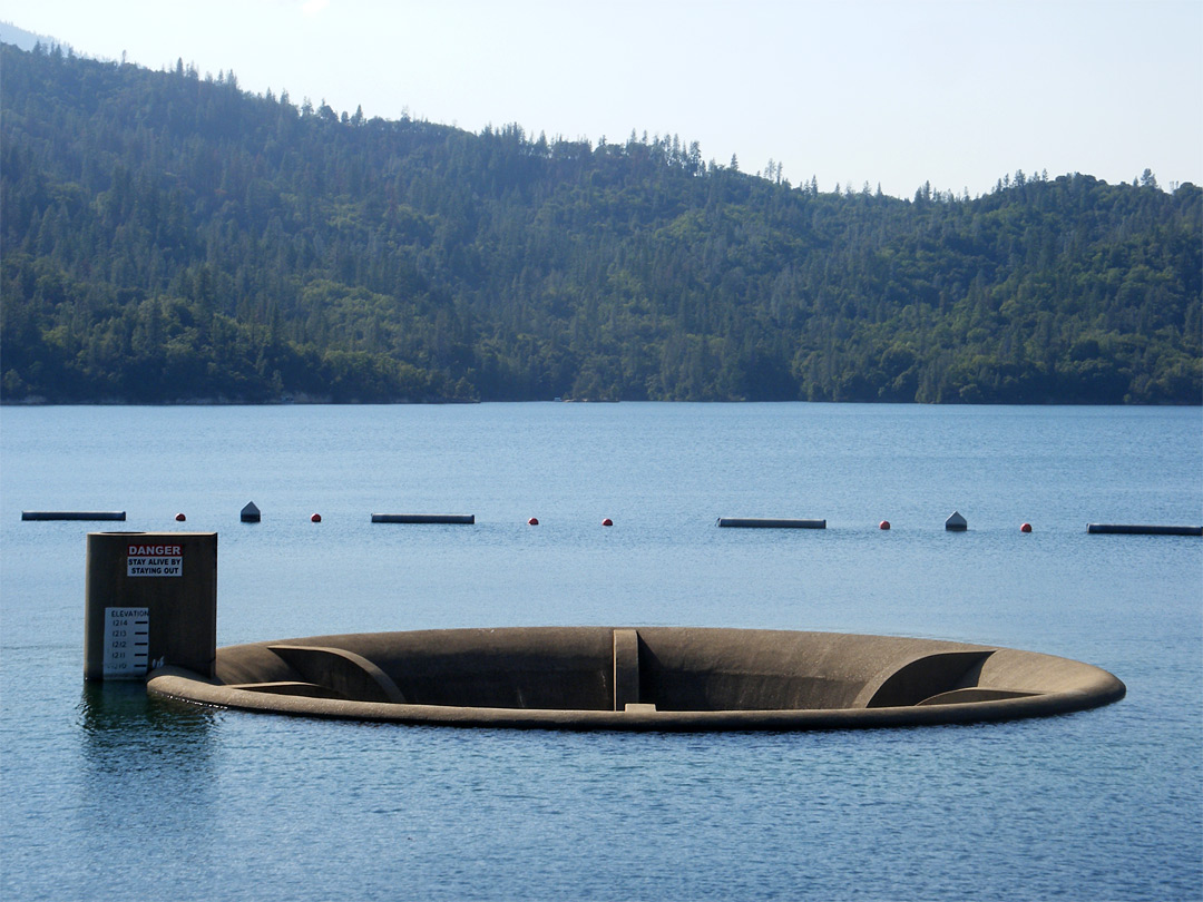
We tried to find Oak Bottom Ditch Trail (the long narrow channel extending from the NW corner of the lake -- see map below), but we must have overshot and ended up in one of the gullies just south of it. It's hard to find your way on these lakes, where everything looks similar and depth is hard to perceive. We continued along the west shore until we arrived at Brandy Creek, a picnic area/trailhead/recreational area where you can rent kayaks or hang out on a sandy beach. Alice landed on shore to enjoy some time on the beach. I carried on for another 45 minutes, determined to get a glimpse of the Clair A. Hill Whiskeytown Dam at the south end of the lake. I also identified an intriguing (but poorly named) feature on the map called the "Glory Hole," which was adjacent to the dam. I told Alice that I planned to investigate. Unfortunately I only had time to turn a corner and view the dam from afar, no glory hole in sight.

Gorgeous spring morning
Alice rounding the bend.
Upon returning to Brandy Creek, Alice informed me that she was very relieved to see me after having read some pamphlets about the lake and finding out what the glory hole was. Read on...

Tree on a rock!
A little history & hydrology... Clear Creek was dammed in 1963 by the Bureau of Reclamation to create Whiskeytown Lake for flood management, water supply for irrigation, and electricity generation. The dam is earthen, which means that it should never be overtopped by water (or it can fail catastrophically). To prevent overtopping of the dam during big storms, the engineers had to include a way for water to drain from the reservoir at a high rate. In a previous post I talked about an emergency spillway adjacent to an earthen dam on Virgil Creek in NY. In the case of Whiskeytown Lake, the spillway is a "Glory Hole" spillway (poorly named), which is essentially a tall drain that water can flow into once the reservoir gets too high. According to this website, the spillway could drain an olympic sized pool in 4 seconds. 

Normal conditions
Overflow conditions
I'm happy to tell you that Big Purple and I did not get sucked into the glory hole, and I will never attempt to approach one again. Luckily the lake was not at flood stage, so the spillway looked more like the top picture!

Date: Monday, May 26th (Memorial Day)
Distance: 8.5 miles
Time: 3 hours