You're currently viewing the old version of this site.
Please visit www.nakedkayaker.com for recent posts and better maps, etc.!
Showing posts with label CCK. Show all posts

05 December 2013

Post-Turkey Sponyaking

Chiddling = Chill paddling
Sponyaking = Spontaneous kayaking
Imprompaddling = Impromptu paddling

It's my favorite kind of day on the water. Never planned more than a day in advance. Simple logistics, slow pace, and good friends (none of this organized crowd-yaking with strangers nonsense). It's the kind of paddle when your PFD is the perfect beer holder. There is no purpose, destination, or expectation, so only pleasant surprises remain.

The day after Thanksgiving I made the trek from North Berkeley to the Kayak Hotel in Oakland. Sadly, it was the first time I've seen my boat since moving to Berkeley two months ago. On this warm sunny morning, I rolled Big Purple down to the docks, dropped her into the water, and took off for CCK. With my iced coffee (not beer!) strapped to the front deck with bungee cords, I looked like a true city girl.

Ten minutes later I arrived at California Canoe & Kayak, the local kayaking shop where I was meeting Doug and his family (bother, sister, and 8-year old nephew). I bobbed about, sipping on my coffee and enjoying the kayak shop atmosphere. When Doug & co. arrived, they loaded into two red tandems and we headed west, towards San Francisco.

Somewhat surprisingly, paddling in the heavily developed Oakland Estuary is never boring. While it's not the sort of isolated outdoor adventure some might desire, it's always fun to gawk at the massive cargo ships, stacked high with shipping containers from across the ocean. Even with the holiday, the cranes were working hard, dangling the packed containers perilously over our heads (ok, not quite over). Three crowded ferries plowed by us, filled with happy consumers excited for the Black Friday deals awaiting them across the Bay. Their wakes reflected from both sides of the channel and lifted us high in the air. In lieu of any photos, here's an awesome link where you can see real time locations of ships in San Francisco Bay.

8-Year-old Daniel and I embarked on a garbage-collection competition. It didn't take long before Big Purple was stacked with 50 cans and potato chip bags. When I offered my stack to Daniel to make the competition more fair, he didn't fall for my trick. So I guess I won?

We made it all the way to the mouth of the Estuary, between the airfield and Middle Harbor Shoreline Park, which apparently hosts concerts in the summertime (on the to-do list). We applied sunscreen, ate some snacks, and turned back towards Oakland.

The route, starting in the estuary and paddling out to the Bay. In this map you can also see Lake Merritt. I lived on the east side of the Lake for two years before moving to Berkeley two months ago.
Date: Friday November 29th, 2013
Time: ~2 hours
Distance ~ 7.5 miles

Thanks to Jeff for a much needed kick-in-the-pants to update the blog. I've skipped quite a few wonderful paddling trips, but it's always easier to start with a simple one :). Stay tuned for a guest post from Jeff in a week or so!

05 November 2012

Drakes Estero, Point Reyes National Seashore

Estero: "small river," "marsh," or "estuary" in Spanish. I looked it up before agreeing to go on the trip. "Drakes" because it's the likely landing spot of Sir Francis Drake in 1579 during his circumnavigation of the world (thank you, wikipedia).

Drakes Bay Oyster Company
We departed from the Drakes Bay Oyster Company around 10am. The Oyster Company manages a pretty extensive network of wooden racks with oyster beds throughout the Estero - when the tide reached a certain water level, we kept scraping the bottoms of our boats on wooden poles just below the surface. There's a lot of controversy surrounding the company -- oyster collection disturbs seal pups, covers eelgrass beds, and leaves some plastic waste floating around the estuary.

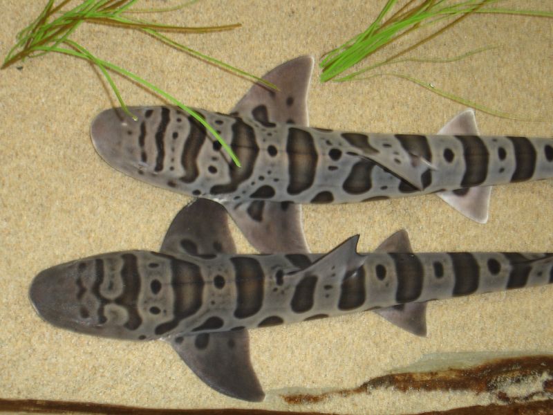
On the way out towards the ocean we turned left into Home Bay, where we discovered a number of bat rays, leopard sharks, jellyfish, and harbor seals. It was my first time seeing a shark from my kayak. Apparently they're harmless to humans, which makes this slightly less exciting. They eat clams, shrimp, worms, and other non-human things. They're native to the west coast (from Mexico to Oregon), and can usually be found in pretty shallow water. Here's what they looked like from my viewpoint:

Leopard sharks - so pretty! Source


The lunch destination was "Limantour Spit," which is the narrow strip of beach that almost cuts the estero off from the greater Drakes Bay (a wide bay on the Pacific Ocean, just south of Point Reyes). The Spit was covered in white Pelicans:


Taking a lunch break on the sand bar at the mouth of the estero.

Big group of BASK paddlers at the launch site.
According to this writeup by the USGS, the unique shape of Point Reyes, which extends approximately 15 km out from the coast, often made it too difficult for ships to sail far enough west to get around the point. Ships often ended up shipwrecked and stranded in Drakes Bay.

Before the 120 meters of sea level rise that occurred over the last 18,000 years (woah), Drakes Estero was just a river valley, which is why it has such a unique shape. It's sometimes said that it looks like a hand, with Limantour Estero to the east as the thumb (see map below). Today the freshwater inflows from the minor creeks are very small compared to the tides and currents flushing the Estero twice-daily.

The sand barrier (Limantour Spit) that builds up in front of the Esteros is created because the prevailing sediment transport moves from south to north along the coast. Since most of the waves reaching California come from the Pacific Northwest, the waves bend around Point Reyes and end up reaching the beach from the south (kind of counter-intuitive), eroding the sandy cliffs from the south end of Drakes bay. The waves push the eroded sand up along Drakes Bay, where it ends up on the beach.

Phew, ok enough nerding out... 


Date: Sunday, October 7, 2012
Time: 4 hours
Distance: ~9 miles

10 June 2012

Introduction to BASK

B.A.S.K. is the Bay Area Sea Kayaking group, which apparently has over 400 members. I joined them shortly after Big Purple arrived to check out the group and meet some nearby paddlers. They conveniently had a new member paddle scheduled two days after my boat arrived on the Oakland estuary, which is only a 5 minute drive from my apartment.

We met up at the public launch site near Jack London Square. For the most part, Jack London Square tends to be completely dead, but on Sundays the farmer's market makes it a popular destination. It always makes me nervous to drive around the Square because a railroad runs along the center of the road. Apparently the maximum train speed is 15 mph, but when a train is coming all the side streets are blocked off, so you could theoretically get trapped on the road/railroad. Not cool.

Public launch at Jack London Square. Photo by Chris Amy.

The public launch also hosts the rental fleet owned by California Canoe and Kayak, which is a local paddling shop. I paddled here once in the fall, and they were able to rent me a plastic avocet (the same type as Big Purple), which was pretty exciting.

I arrived 5 minutes before the meeting time, which is apparently late for BASK-ers because everyone was already there! This was somewhat odd since I usually find myself having to drag people out of bed to go paddling with me. We launched promptly and paddled east, into the "estuary". It's certainly not the most scenic paddle, but we saw some interesting sites along the way. The route took us under 4 bridges, many of which opened to let boat traffic through:

Drawbridge #1
Drawbridge #2
Big barge from Portland. Photo by Chris Amy.

We stopped half way for lunch at the Tidewater Aquatic Center. The shear volume of snacks the BASK-ers brought to pass was quite astounding, and I will certainly bring more to contribute next time! Yum...

Chris took a bunch of other lovely photos, which can be found here.

Date: Sunday, May 6, 2012
Time: 3 hours ?
Distance: 7.8 miles