At 8:20am on Easter morning, Alice and I simultaneously pulled into our favorite Park-N-Ride in San Rafael. We have a history of perfect timing - we're both 10 minutes early. We loaded White Lightning onto my car (next to Big Purple) and headed up the 101. Estero Americano flows into Bodega Bay, roughly 1.5 hrs from the Bay Area. The launch site is at the end of a dirt road that spurs off the intersection of Marsh Road and Valley Ford Franklin School Road. Another kayaker arrived shortly after us, and spent 20 minutes urging Alice and I to join a kayak racing club in Berkeley.
Parked at the launch site off Marsh Road
Estero Americano is fed by Americano Creek and forms the boundary of Marin County with Sonoma County. The Estero is not always deep enough to paddle - water levels can fluctuate significantly depending on flows in Americano Creek (rainfall), tide levels, and whether or not the lagoon is open or closed at the ocean. We weren't sure whether the lagoon was open, but I've been eyeing this paddle for over a year, so we took a risk and went for it! There is virtually no access by car or visibility from roads during the 6 miles trip between the launch site and the Pacific Ocean - the best way to see it is by kayak/canoe.
The trip begins as little more than a narrow muddy channel winding between flat dairy pastures. Thanks to some recent rain, the fields and hillsides were bright green. Curious cows approached the channel banks to grunt and say hello.
Nena meets cows. Photo by Alice Miller.
Alice checking out Whale's Tail rock
The channel widened after 2 miles amongst the cows. Adjacent hillsides rose, and salt marshes and mudflats replaced the pastures. The last couple miles were by far the most majestic, with steep green hillsides flanking the wide Estero. Alice and I both felt that we had been transported to New Zealand or another more dramatic landscape. A strong wind picked up along this stretch, increasing our sense of isolation as we paddled independently (conversation during windy kayaking quickly leads to sore throats).
And suddenly you're in New Zealand. Photo by Alice Miller.
We rounded the last bend around noon and were welcomed by our own private sandy beach. The mouth of the Estero was open, and the lagoon was still draining (much to our surprise - low tide was at 10am). We dragged our boats up onto the beach and went exploring. Alice walked to the south end of the beach, while I checked out the mouth and basked in the sun.
Exploring the mouth of Estero Americano. Photo by Alice Miller.
The beach at Estero Americano, facing south
Alice taking pictures of the beach
The return trip passed quickly, and we met a cow carcass along the way. Alice was slightly traumatized, as Easter is supposed to be about rebirth rather than death. I guess that's what happens when you choose kayaking over Easter mass.
Cow carcass
Date: April 20, 2014 Time: ~5 hrs (including 1 hour of sunning on the beach) Distance: 11 miles
[This post has been in draft form for 1.5 months, so I figured it was time to accept its imperfections and wrap it up. Lindsey, my fellow king-tide tour-guide also wrote a post, available here]
Choose inundation over inebriation** and celebrate King Tides because it's much more exciting than celebrating the New Year. Why? [Thanks to Lindsey for helping brainstorm this list]
The party don't stop: They happen for 3 days, so you can "Cheers!" and wish everyone a HAPPY KING TIDE at least 3 times. And since they happen in different places at different times, you can chase the tide and have that exciting moment multiple times in a day.
The party don't stop #2: Another good reason to drink at the Embarcadero
Play; Splashing in puddles an getting hit by waves in normally dry places.
Excitement: Fleeing men in golf carts
See the future: See what the world will look like every day with sea level rise.
And, because this is a kayaking blog... Expanded kayaking territory. As the water rises, it moves into nearby low-lying areas that are not normally wet, creating new spaces for kayakers to explore.
** A wonderful expression coined by James Jackson What are King Tides?
King Tides are the most extreme astronomical* tides that occur every year. A couple times per year, the earth, moon, and sun align in a way that creates the largest tide range. These days it's common for people to compare King Tides to sea level rise. The high tides that we see during the 2013 King Tides will likely happen on a daily basis in ~50 years (and the future King Tides would be even higher!). This year I decided to visit the coast during the King Tides so I could get a sense of what sea level rise might look like (on a good day, without storms).
* Sometimes non-astronomical forces, like weather/waves/storm, can raise tide levels for short periods of time. These changes are less predictable, while King Tides are regular and predictable.
Lindsey, Doug, James, and Barry were my tide-buddies for this year's celebration.
King Tides at the San Francisco Embarcadero (12/31/2013)
On the morning of New Years Eve Lindsey and I snuck out of the office and walked a half mile to the Embarcadero waterfront in San Francisco. The king tide was scheduled for 9:48 am (a 7.07 foot tide). We went to Pier 14, between the Ferry Building and the Bay Bridge, where the King Tides have flooded the Embarcadero in the past. Here are some photos:
Stairwell flooded, and waves breaking onto the sidewalk.
A video of waves lapping over the Embarcadero:
We (Lindsey, Barry, and I) also returned later at the very lowest tide of the day (during King Tides, the lowest tides get very low, so it's a great time to go tide-pooling!). We ran into one of Barry's friends who promptly offered me and Lindsey a ride on his bike-taxi to the Embarcadero. We celebrated the low tide with a six pack of beers, and cheers-ed! at 4:42 pm, when the tide hit -1.35 feet. Here's one of many low-high comparison photos we took:
Extreme low tide:
Extreme high tide:
And the view of San Francisco at sunset wasn't so bad either:
King Tides at Beach Boulevard in Pacifica, CA (1/1/2014)
The next day, Lindsey and I picked up James and Doug for our first King Tide tour of 2014. Our first stop was Beach Boulevard, CA. We also decided to form a band called the King Tide Kids. Cover album:
The crew: James, Doug, Lindsey, and Nena
No beach at high tide, with waves crashing on the massive revetment
We watched a group of kids standing at the edge of the railing daring each other to stay when big waves crashed over the seawall.
Big waves rolling under the Beach Boulevard Pier
King Tides in Redwood City (1/1/2014)
Our final stops were in Redwood City, where we discovered a dock completely bent out of shape by the extreme high tide:
We (ok, I) decided to jump this fence to get a better view of the Bay at the end of the levee. Minutes later a small golf cart came bumbling along, catching up with us when we finally reached the view point. Two very angry men questioned us: "What was going through your mind when you walked past the 'No Trespassing' sign?" Thankfully Lindsey and Doug fielded the questions while I carefully avoided eye contact.
I've been a bit scarce over the past six months thanks to a lovely series of exams to become a professional engineer (fingers crossed!). Even before the exams were over, Alice (new paddling friend in the Bay) and I were scheming to do a coastal paddle from Muir Beach to Rodeo Beach (just north of the Golden Gate). Even though we've both done a bit of coastal paddling, we were a bit nervous to head out by ourselves. Alice posted her first trip to the BASK (Bay Area Sea Kayakers) list-serve, and five other expert BASK paddlers joined us (Gordon, Don, Joe, Bert, and Ross). Gordon offered to carpool with me since we were both coming from the East Bay, so I had the exciting experience of getting a ride in his old sand-yellow mercedes station wagon!
Where Redwood Creek meets the ocean. The Creek is currently undergoing a restoration project to restore some of its natural pathways and habitats after years of farming/development.
The path to the ocean is a bit long, but we shared some wheels and hands to transport boats along the sandy trail to the beach. We gathered on the beach for Alice's first safety talk. We felt safe:
From Joe (arms wide open) clockwise: Don, Ross, Nena (me), Gordon, Alice, and Bert on the camera. Photo by Bert V!
Even though conditions warned of a small craft advisory, the expert BASKers had never experienced a calmer day on the water at Muir Beach. We launched through a little surf and headed south along the rocky coast. We paddled rocks, the swell lifting us up and down between steep spires on either side. I mostly avoided the narrow spaces, but a few of us did a bit more rock gardening.
Photo by Bert V.
Three miles down we reached Rodeo Beach. The northern end of the beach is known for dumpy waves that make landing tricky. Even though conditions were calm, we decided to have lunch on the south end.
Lunch spot on Rodeo Beach. Photo by Joe P.
After lunch we headed back north towards Muir Beach. At the rocky point just before Muir Beach most of the group chose to paddle close to the point between the rocks. I chose to paddle out and around, which turned out to be a bit bumpier than I expected. The waves were pretty "confused," coming from two different directions and yanking my boat side to side. Thanks to some quick braces I didn't have to practice my roll, but it was certainly exciting!
There are some fantastic arches and caves along this route. Photo by Joe P.
We passed Muir Beach and continued north "just to the next rock" three times :). When we returned to Muir Beach it was completely transformed - covered in people enjoying the sunny day. We were dodging babies to land on the beach, and had quite the reception. "Where did you come from?" asked the kids with wide eyes, as they scrambled into our boats. I guess we do look like aliens in all our gear...
At the end of the day Alice, Gordon, Ross, and I stopped by the Pelican Inn to enjoy some drinks in the sunny lawn.
Obligatory post-trip Muir Beach factoids
[I should really start doing this before I go on trips]:
Muir Beach lies in the Marin Headlands on the Pacific Coast of Marin County (ok, I knew that).
Before Europeans arrived, the area was a wild and dramatic landscape, with bears, bald eagles, mountain lions, bobcats, elk, and many Coast Miwok people who moved from village-to-village.
The Portuguese began arriving on whaling ships in the 1850s from the Azores to start dairy ranches. The beach and entire hillside was (apparently) purchased for $10 by a Portuguese settler who built a hotel and some cabins. (How big is a $10 gold coin in the 1850s?)
The Old Tavern on the beach used to be a dance hall and host "psychedelic bands," until it was removed in the 1960s and the beach was acquired by CA State Parks. A few members on our trip remembered this Tavern fondly.
See you again soon, Ocean.
Approximate route (Muir Beach at the red marker, Rodeo Beach at the south end of the red line):
Estero: "small river," "marsh," or "estuary" in Spanish. I looked it up before agreeing to go on the trip. "Drakes" because it's the likely landing spot of Sir Francis Drake in 1579 during his circumnavigation of the world (thank you, wikipedia).
Drakes Bay Oyster Company
We departed from the Drakes Bay Oyster Company around 10am. The Oyster Company manages a pretty extensive network of wooden racks with oyster beds throughout the Estero - when the tide reached a certain water level, we kept scraping the bottoms of our boats on wooden poles just below the surface. There's a lot of controversy surrounding the company -- oyster collection disturbs seal pups, covers eelgrass beds, and leaves some plastic waste floating around the estuary.
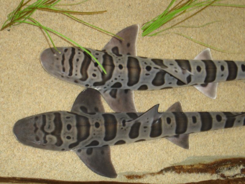
On the way out towards the ocean we turned left into Home Bay, where we discovered a number of bat rays, leopard sharks, jellyfish, and harbor seals. It was my first time seeing a shark from my kayak. Apparently they're harmless to humans, which makes this slightly less exciting. They eat clams, shrimp, worms, and other non-human things. They're native to the west coast (from Mexico to Oregon), and can usually be found in pretty shallow water. Here's what they looked like from my viewpoint:
The lunch destination was "Limantour Spit," which is the narrow strip of beach that almost cuts the estero off from the greater Drakes Bay (a wide bay on the Pacific Ocean, just south of Point Reyes). The Spit was covered in white Pelicans:
Taking a lunch break on the sand bar at the mouth of the estero.
Big group of BASK paddlers at the launch site.
According to this writeup by the USGS, the unique shape of Point Reyes, which extends approximately 15 km out from the coast, often made it too difficult for ships to sail far enough west to get around the point. Ships often ended up shipwrecked and stranded in Drakes Bay.
Before the 120 meters of sea level rise that occurred over the last 18,000 years (woah), Drakes Estero was just a river valley, which is why it has such a unique shape. It's sometimes said that it looks like a hand, with Limantour Estero to the east as the thumb (see map below). Today the freshwater inflows from the minor creeks are very small compared to the tides and currents flushing the Estero twice-daily.
The sand barrier (Limantour Spit) that builds up in front of the Esteros is created because the prevailing sediment transport moves from south to north along the coast. Since most of the waves reaching California come from the Pacific Northwest, the waves bend around Point Reyes and end up reaching the beach from the south (kind of counter-intuitive), eroding the sandy cliffs from the south end of Drakes bay. The waves push the eroded sand up along Drakes Bay, where it ends up on the beach.