You're currently viewing the old version of this site.
Please visit www.nakedkayaker.com for recent posts and better maps, etc.!
Showing posts with label road trip 2014. Show all posts

05 August 2014

Day 18: Sleeping Bear Dunes National Lakeshore

The Legend of Sleeping Bear (courtesy of NPS)
Long ago, along the Wisconsin shoreline, a mother bear and her two cubs were driven into Lake Michigan by a raging forest fire. The bears swam for many hours, but eventually the cubs tired and lagged behind. Mother bear reached the shore and climbed to the top of a high bluff to watch and wait for her cubs. Too tired to continue, the cubs drowned within sight of the shore. The Great Spirit Manitou created two islands to mark the spot where the cubs disappeared and then created a solitary dune to represent the faithful mother bear. You can see the two islands in the zoomed out map below (we paddled along the blue lines - see zoomed in map further down in this post).

Our trip (blue line below "Sleeping Bear Dunes") and the two baby bear islands from the legend
The launch site: Village Park in Empire, MI
Today we kayaked along the shore near the sleeping bears. Jeff and I drove across the UP and down to Empire, MI in 5 hours this morning, where we met up with Elizabeth (my future roomie in Delft, who I'd never met before!) and her sister Ali. Jeff and I successfully jammed up the parking lot waiting for a spot to free up, but the car was parked things went smoothly. Parking was ~$1/hr. Sleeping Bear Surf and Kayak delivered 3 kayaks to the Village Park beach from their shop a few blocks away. The wind was whipping up some small, choppy waves on Lake Michigan, but we launched successfully (with an intentional refreshing dip by Elizabeth and Ali before departing). 

Elizabeth (front) and her sister Ali (back) paddling into the wind
Elizabeth and I chatted about Delft and "quitting" our jobs (Elizabeth is also going to work part time remotely) as we paddled into the wind. Along the shore the beaches were very narrow, with an actively eroding scarp (I was later informed that water levels in the Great Lakes are very high this year due to the extremely stormy/snowy winter). 

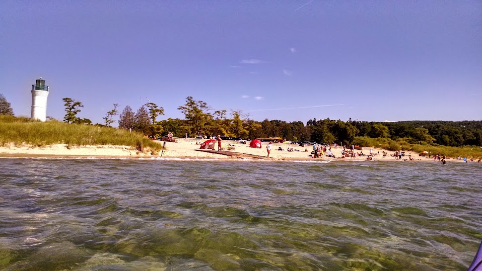
Our first stop was North Bar Lake, a small freshwater lake attached to Lake Michigan through a shallow channel. We dragged our kayaks over the low sandbar at the mouth of the lake and weaved through swimming children, trying not to be pelted by the various beach-related toys flying through the air. The water in the small lake was significantly warmer than in Lake Michigan. 

Arriving at the entrance to North Bar Lake. The water was so clear!
The crowded inlet channel to North Bar Lake
We continued up to the southern tip of the Sleeping Bear Dunes to have a brief photo shoot. We watched tiny tourists running/rolling down the 400-ft dune in the distance and wondered how they would ever get back up. The return trip was significantly easier/speedier thanks to the tailwinds pushing us along. 

Elizabeth and I doing the kayak-win-cheer!
Jeff and the gorgeous view of Empire Bluffs in the other direction
Date: August 5th, 2014
Distance: 7 miles
Duration: ~4 hrs

A zoomed-in version that shows the launch site (Village Park in Empire), our stop at North Bar Lake, and the bottom tip of the huge sand dunes.
The Non-Kayaking Portion: After our paddle, Elizabeth gave us all a ride in her convertible (first time, woo!) to Glen Arbor where we visited Cherry Republic. Elizabeth rightfully called this a "campus," as there are three buildings dedicated to cherries: snacks (free samples galore), drinks (cherry wine and hard cider), and ice cream. Our stomachs full of cherries and cheez-its (we'd snacked on these in the car), we returned to Elizabeth/Ali's home in Traverse City. Together with their parents, they cooked up a delicious dinner (BBQ chicken, pasta salad, caprese salad, and mango salsa), which we shared on their back patio with various pink drinks. We were informed that there was a skunk stuck to a fence somewhere on the property and that a snack had been spotted earlier, but otherwise the garden was beautiful and peaceful. We spent a great deal of time examining each other's kayaking tans/burns (it was super sunny today). A few showers later, we chatted about all things Dutch. In particular, we stalked our future Delft friends on Facebook, discussed gravy sticks that come out of vending machines, and mapped out a plan to bike/ferry to London. I can't wait to move to the Netherlands!

First convertible ride ever. Headbands are essential in the windy back seat!

30 July 2014

Day 12: In Transit - Orcas Island to Missoula

“beep beep beep beep” Sara’s watch alarm beeped quietly inside her sleeping bag. I was already awake, as often happens during 5:45am wake-ups. My phone alarm rang minutes later to a much louder tune. We packed up camp, loaded our damp kayaking gear into the trunk, and departed for the 7:15am ferry on the other side of Orcas Island. This time my car was loaded next to a massive lumber truck on the left and sewage truck on the right (previously it was a flammable liquids truck). Apparently when you have kayaks on the roof you are lumped with the big ones.

When we arrive in Anacortes at 8:15 we'll drive down to Seattle and return Sara’s kayak Renaldo. They've become close over the last 5 days and it will be a tearful goodbye. In Anacortes I'll be careful not to speed, as Bridget was awarded a $200 speeding ticket after disembarking the ferry a couple days ago. We'll be mailing Bridget’s sleeping bag, sun hat, and some other goodies back to Oregon after we return Renaldo. After I drop Sara off at the airport, I’m headed east towards Spokane.

Don’t know where I'm sleeping yet tonight! I’m going to try to get as far east as possible today. Rya, a friend that I met in Santa Cruz back in my hostel-staying days, lives in Colville now, 1.5 hrs north of Spokane. She offered her couch to me, but I'm struggling with adding 3 more hours of solo driving. I may just camp in a field tonight! I just got word that Devin will be in Bozeman when I'm there tomorrow night, so that’s a nice surprise! Our last meetup was during my previous cross-country road trip with Marika a few years ago, before I moved to California and Devin and Anna moved to Vermont.

Okay, the ferry is arriving in Anacortes shortly so time to close up and head down to the car!

Next morning update: Yesterday went more or less as planned. After I dropped Sara off at the airport I drove east to Spokane, where Rya and I planned to meet for dinner. I was early, so I blogged at the Rocket Bakery, which had speedy internet and delicious lemondade:


Rya's truck broke down (likely overheating - it was 102 degrees!) north of Spokane, so I drove up to meet her at Twigs. It was fun catching up - she's engaged and in the middle of building a cabin by a lake in Colville. I couldn't stay long as I was headed to Missoula (3 hours away) for the evening. I ended up solo camping at a National Forest campground an hour outside Missoula. Some views from the drive...


North of Spokane

29 July 2014

Day 11: Speedy Sunset Paddle in East Sound, Orcas Island

I slept in a couple hours longer than Sara to try and rid myself of a standard migraine (which usually lasts through 2 or 3pm the next day). Around 10:30 we headed into town (Eastsound) for some coffee ands discovered pistachio fig chocolates and mint ice cream. Mmmm breakfast! At a little park on the north end of East Sound, Sara made some phone calls to work and Southwest baggage. Southwest informed her that her second bag, which contained all of her camping/hiking/running gear, was considered permanently lost. Southwest agreed to reimburse her for the cost of the items, with depreciation, but it’s not clear exactly what that means. It’s a sad day :(

We made a stop to the grocery co-op where I purchased bulk spices in tiny bags, perfect for camping (each bag was ~25 cents!). Our Mexican-style veggies/beans/couscous will be twice as delicious tonight. Now I’m sitting by Cascade Lake in Moran State Park, only a mile or so from our campsite, while Sara hikes to some waterfalls nearby and I try to rid myself of this lovely headache. 

My blogging view
Next morning update: After Sara returned from her hike we made an excellent lunch-dinner of toasted pine nut couscous with sautéed onions, peppers, squash, and kale with black beans and spices. 


We relaxed on our respective picnic table benches for a while to digest before getting our butts in gear to go kayaking. We selected Cascade Bay, at Rosario Point as our put-in location. Naturally, we made a quick ice cream stop at Lopez Island Creamery and had some amazing Toffee Coffee and Rocky Road deliciousness. Cascade Bay is half way down East Sound and only a 5 minute drive from our campsite. We launched around 6:20pm and paddled south along the east shore. 

Cascade Bay launch beach
An hour later we were very energized (thanks, ice cream!) and decided to aim for the point at the mouth of the Sound. As with many points, we discovered another one… and another one… after it until we finally reached the bottom of the island. We turned the corner and got another view of Mt. Baker. There was a breeze, but there was little to no current. A time check showed that we had been paddling for 1.5 hrs, and would only get back to the launch site by ~9:20pm, after dark. We turned around and booked it back up the shore. Shortly after turning around we saw some splashes in the distance that we assumed were seals. Minutes later I saw a seals head pop up in front of Sara’s kayak. The next time it popped up it had a dorsal fin! The porpoise surfaced a few more times as it swam away from us. Another marine mammal spotted!


We chased the sunset along the island’s western hills until we arrived back at the launch site around 8:50pm. As always, the moment we started stripping in the parking lot 4 families came walking towards us from all directions. We drove back to the campground with Sara’s favorite country song on the radio. “Swarms of adolescents,” as Sara would call them, were wandering the campground roads. This week the park is hosting a cross-country running camp that clearly reserved every site on the island except ours. We showered, reorganized the car in anticipation of our early departure the next morning, read, and went to bed by 11.

Date: Tuesday, July 29th 2014
Distance: 9 miles
Duration: 2.5 hrs

28 July 2014

Day 10: Sunset Paddle with Mt. Baker and a Hike up Mt. Constitution

Monday morning we “slept in” and made a dinner-breakfast of spaghetti with tomato sauce, supplemented with mushrooms and chard – yum! Sara and I packed up our tents and left camp earlier than the rest of the crew. Everyone else was headed back to Anacortes later that morning, but we were headed to Orcas Island to continue the second half of our San Juan Islands trip. Even after multiple calls to the Southwest Airlines baggage counter (at 3 different airports), there was no indication that Sara’s two checked bags would be delivered, so we headed into Friday Harbor to replace some of the lost items. A 45-minute shopping spree later, Sara was the proud owner of some new chacos, underoos, paddling gloves, and other items. We made the usual stops for water, ice, and coffee before boarding the inter-island ferry. The ferry from San Juan Island to Orcas Island took ~1 hour, during which I wrote postcards and Sara enjoyed the warm sun on the deck.


Orcas Island is shaped like an upside-down U, with the ferry terminal on the west end and Moran State Park (our campground) on the east side. During our drive we stopped at Eastsound, at the inland end of East Sound (the water body that makes the island look like a U). We stopped in at the first kayaking shop we encountered and purchased a map of the island. One of the employees was incredibly helpful and marked all the launch sites around the island, explaining which would require checking the tides and which are generally current-less. He even gave us their phone number in case we wanted to call for a weather update. Upon arriving at Moran State Park, the check-in lady gave us some hiking recommendations that we pursued after setting up camp. We settled on a 6.7 mile loop that starts at Mountain Lake (a couple miles from our campsite), moves steeply up Mount Constitution past Summit Lake, drops again to Twin Lakes, and meanders back along the west side of Mountain Lake. The views from the top of Mt. Constitution were stellar – the day was perfectly clear and we had nearly 360 degree views of the San Juan Islands and more distant mountain ranges. Snowy Mount Baker was most prominent on the horizon:


The deep and crystal clear waters of Mountain Lake beckoned us upon our return to the car, so we jumped in to refresh ourselves before driving to the northern-most point of the Island (end of North Beach Road) to go for a sunset paddle. Unlike in California, the beaches here are not necessarily public. At the end of the road was a narrow parking lot fronted by a cobble beach with views of the Cascades to the left and Mount Baker to the right. Signs marked private property on either side of the very small public beach. We perched ourselves on a large driftwood log (abundant in these islands) to have a lunch-dinner of pitas with the usual veggie/hummus toppings, complete with honey-topped saltines for dessert. 

We were saddened by the private property signs
Stuffed with delicious food, we speedily unloaded Big Purple and Renaldo onto the increasingly crowded beach (it was empty when we arrived). After a brief mishap that resulted in Renaldo dumping Sara into the water (thank god for the wetsuit!), we were headed east along the shore. It was 7:20pm, so the sun was still high in the sky. We paddled towards snowy Mt. Baker, with glassy waters all around. A seal splashed in distance, and small jumping fish greeted us every stroke of the way. We continued to the northeast point of the island, where we spent a few minutes having a photo shoot in what might be the most scenic view I've ever experienced in my kayak. 


Paddling towards Mt. Baker


The sun was still blazing at our backs, so turning around wasn't an option (way too painful on the eyeballs). Instead, we hugged the shady parts of shore and turned into a small rocky beach where Sara searched for colorful pebbles and I took a “nap” in my boat. When the sky began to turn orange and the sun’s intensity dropped, we started heading back, witnessing a gorgeous sunset along the way. Mt. Baker evolved to different shades of purple and orange behind us. After the sun went down, the mountain ranges turned different shades of blue, grey, and purple, and Sara noted that this looked like every postcard she'd seen. 

Rocky point where we stopped to wait for the sun
Back at the beach, we quickly loaded the boats and wet gear into the car, with one bystanding biker expressing his love for Renaldo. Sadly, my head was pounding from a migraine, so we headed straight back to the campsite (#112) with only a quick stop to pick up water and a wine opener. Sara enjoyed an evening of showering, reading, and red wine, and I went immediately to bed!

Date: Monday, July 28th 2014
Distance: 3 miles
Duration: 1.5 hrs?

27 July 2014

Day 9: Kayaking with Orcas in Haro Strait!!!

Another (attempted) early start! At 6:50am (only 20 minutes late) we departed the campsite, made a quick-ish coffee stop in Friday Harbor, and continued to our second San Juan Island kayaking destination: Haro Strait. This strait runs along the west side of San Juan Island and is known as the best location for orca whale sightings. The main public put-in site is at Smallpox Bay in San Juan County Park, which is apparently where a number of Indians plunged into the icy cold water to rid themselves of smallpox and instead died of pneumonia. 


At the put-in we obtained a $7/boat permit, which requires watching an 11-minute video about boating regulations related to whales. We learned that you must stay 200 yards away from whales, and 400 yards away from the path in front of them (since they might redirect to the left or right). Fines can be as high as $32,000! A sign in the check-in office stated that whales had not been seen for 4 days, but we kept our hopes high and launched into scenic Smallpox Bay. 


We paddled north, sticking close to the steep, rocky coast. Once again, the water was crystal clear, except where the kelp forests hung thick. 

Ale and Bridget with a seal!
We arrived at Mitchell Bay around 9:30 am, and paddled point-to-point across Mitchell Bay, Mosquito Pass, and into Open Bay. At 10:20 we arrived at Open Bay and decided to have “free time” and meet back up at 11:30 to return with the outgoing tide. Alex and Maria headed to a secret beach on the north side of the bay while the rest of us wandered towards the back of the bay and eventually decided to paddle out around the point of Henry Island. We joined Alex and Maria at the secret beach at 11am for a quick lunch. From the beach we could see out into Haro Strait, where boats seemed to be gathering and moving together up the Strait. Moments later we got our first distant glimpse of a dorsal fin. In what must have been our speediest launch yet (5 minutes from half-eaten-sandwich to launched kayak), we made our way out to the Strait. At least 10 various motorboats were moving constantly north, and we kept our eyes peeled. WOOOSHHHH! We heard our first blow spout. Seconds later we saw a dorsal fin glide gracefully out of the water. Over the next hour we saw 4 different pods of orca whales swim by (at a distance, of course)! As many as 8 whales came up for air at the same time. I tried to take photos, of course, and here’s the best I could do. Many of the whales went right up to the point where we had poked our boats around just 30 minutes earlier. 

KAYAKING WITH ORCAS

Bridget wishing she could ride the orca
On the way back we sighted some seals on the rocks:

And everywhere we paddled we found monster kelp:


More kayakers had arrived on scene by the time we approached the launch site. The sun was blazing, and the heat drove me to practice some rolls in Smallpox Bay. Instant ice cream headache ensued, and I dissuaded Sara from practicing another assisted rescue. Instead, Sara and I landed, retrieved the cars, loaded boats, and dried gear while the rest of the crew paddled around some more and sunned on the beach. Fast forward to packed-up cars and strapped-on boats (the last time loading the ridiculous tandems!), Sara, Bridget, Ale, and I went for a hike at Lime Kiln Point State Park, just a few miles up the road. The “hike” began with 2 everything bagels with cream cheese. The trail took us along the coastal cliffs, where many non-kayakers view orcas from afar. A small lighthouse was open to the public and shared lots of orca-related info, including sighting counts and visitor trends (did you know that orcas had the most visitors in 1997? We decided this was when Free Willy was released, or maybe one of the sequels…). Bridget and Ale “tattoo”ed themselves in many places with the orca visitor stamps. 

Ale and Bridget with orca tattoos


We retrieved our sunning compatriots before returning to Tim’s place to drop of the Monster Ships. We returned Renaldo and Big Purple to their proper locations on Tess, the blue Subaru. The whole group made a stop in Friday Harbor for some cash, milkshakes (I’m still dealing with the sugar headache), clean underwear (no success), and mini bottle of soy sauce (success). Feeling sticky and hot, Sara, Bridget, Ale, and I went for a swim in a pristine-looking lake (labeled as “Sportsman Lake”) near the campground. A nearby biker turned the corner to the beach at an unfortunate moment with 75% of the group was mid-bathing-suit-change. Bridget dives into water: “EWWWW seaweed!!!! Ok I peed in the one spot without seaweed.” *Exits water* Nena dives into water: “So much warmer than ocean water!! Bridget, you’re so gross.” Ale dives into the water “Ewwww smells like pond water!!” Sara dives into the water: “EWWW tastes like pond water!” Our “swim” was really just a quick dunk.

Now we are huddled in our tents resting up for a big bonfire night on the beach. Sara is drinking wine and journaling in the tent (she just spilled wine all over her orca journal) whilst I sit here typing on my MacBook pro.

10:23pm update: Everyone seems to be snoring in their tents, and once again we’ve lazily replaced our extravagant dinner plans with cashews and fruit. Sigh… goodnight!

Date: Sunday, July 27th, 2014
Distance: 10.5 miles
Duration: 6 hours?

26 July 2014

Day 8: Ferry to San Juan Island, Paddle Griffin Bay

5am: it’s time to wake up for the earliest ferry! In classic Nena-style we (Nena/Sara/Bridget/Ale/Alex/Maria) took the first ferry from Anacortes to Friday Harbor at 6:25am. We were directed to Lane #4 where we parked, ate yogurt and cereal, and watched a gorgeous sunrise. We wandered into the waiting area and found a Seattle’s Best coffee machine, which delivered wonders for $1.50. “Now boarding the 6:25 ferry to Friday Harbor.” Oh crap, we return to the car just in time to board the ferry, parked behind another pair of kayakers and next to a massive flammable liquids truck. The ferry to Friday Harbor lasted ~1 hour. 

Sunrise at the Anacortes Ferry Terminal
In the "cars with boats" lane.
We drove straight to San Juan Expeditions (a.k.a. Tim) where we immediately discovered (no surprise here...) that Bridget’s factory roof rack was not wide enough to hold two massive tandem sea kayaks (henceforth referred to as the “Monster Boats”). Eventually it was decided that since Tess’s (the blue Subaru) rack was wide enough, she would transport the baby pink and neon green Monster Boat while Fernando and Big Purple cuddled on the top of Bridget’s SUV. To this day, we continue to regret not taking a photo of the Monster Boats (which are significantly longer than my car) on the roof. Tim was quite helpful, assisting us with strapping down the boats and making recommendations for paddling routes.

We decided to keep things simple for our first day and paddle in Griffin Bay, which was only 5 minutes from the kayak rental shop and not really affected by tidal currents. Jackson Beach was an easy launch site with plentiful/free parking, two wide ramps, and sheltered waters. An old grey/blue cannery building sits adjacent to the harbor and marked the otherwise hidden entrance for our return. Our compatriots drank some beers and whiskey at 9am before launching. We paddled south, sticking close to shore and inshore of Dinner Island. 

Nena, Ale, and Bridget on Griffin Bay
A couple hours later we arrived at Third Lagoon for a lunch break. Here, a wide cobble beach strewn with sun-bleached driftwood and punctuated by small stands of pickleweed separates a lagoon from the bay. We enjoyed our extravagant lunch of stale pita bread, hummus, raw kale, carrots, snap peas, and fermented avocado. 

Third Lagoon
Sunny nap at Third Lagoon.
Before turning back to the launch site, we paddled to Harbor Rock at the Bay’s edge. Here we observed a crowd of seals bobbing in the water. The crystal clear water allowed us perfect views to the eelgrass, kelp, crabs, and other life below. Eventually, we took a shortcut straight across the Bay to return to Jackson Beach, spotting a bald eagle soaring over our heads along the way.

After paddling, we drove to our campground at the “Lakedale Resort,” which is on the northeast corner of the island and encompasses a series of freshwater ponds/lakes privately owned by the resort. We stayed at site 206, which is on the far end of the campground. Our site was so small that we could hardly find a spot for a single tent, let alone 3. Bridget parked her car across the road and Sara and I put our tent in the parking spot (Sara really loves the sound of cars rapidly approaching the tent).

A few hot showers later, we cooked up some herbed couscous and steamed broccoli (with a lovely sprinking of canned tuna) before heading to bed nice and early.

Date: 7/26/2014
Distance: 10 miles
Duration: 5 hours

25 July 2014

Day 7: Errands in Seattle and Deception Pass State Park

I slept in at the AirBnB until ~9am on Friday, lounging, doing some work, and discovering free snacks in the cupboards until it was time to pick up delayed-Sara at the airport. One drive-through coffee later, I stopped by REI to pick up a couple bottles of fuel for Sara’s stove. I waited outside the airport for ~30 minutes before receiving a text from Sara: “just landed… no bags… I’m back in line… totally lost.” We immediately made a list of the essentials that would need replacing in order to have a remotely successful camping trip: sleeping pad, socks, sleeping bag, sun hat, kayaking clothes. Bridget had not yet departed Corvallis yet, so she kindly agreed to bring the extra supplies. We made another stop at REI to pick up a sleeping pad and stove (yay, now I have a functioning stove!). 

Sara testing out some cheap sleeping pads (vetoed)
After a delicious lunch in Capitol Hill, we stopped at Einstein Books (recommended as the best bookstore in Seattle) for some camp-reading material and re-stocked on food at Safeway. We picked up Sara’s excellent red kayak, swiftly named Renaldo, at Moss Bay kayaking. On our last trip Sara’s red rental call was named Fernando, so this was in keeping with the trend. We sipped Guinness and cider on a sunny patio on Moss Bay before making the 2 hour drive to Deception Pass State Park – our first campsite. The park was strategically located 20 minutes from the Anacortes Ferry Terminal where we were scheduled to depart at 6:25am the next day. We drove over Deception Pass at sunset and took in the gorgeous bridges and views for a few minutes before continuing to our expensive/tiny campsite. 

Bridge over Deception Pass
We fashioned a bed for Sara out of miscellaneous items in the car and attempted to sleep for a couple hours before Bridget and her crew arrived at midnight with the sleeping bag. All in all, a preparation day for our exciting kayaking trips ahead!

19 July 2014

The Start of the Journey: Goodbye San Francisco Bay

Today marks the start of a 24-day cross-country road trip from San Francisco to Boston. I'll be heading up the west coast through Corvallis, Portland, Seattle, and the San Juan Islands before taking a turn and heading east through Bozeman, Bismarck, the Great Lakes, Rochester, NYC, and finally Boston. My hope is to post every couple days, which means my writing will be much more stream-of-consciousness. Apologies in advance for the typos and lack of research. I'm excited to share my experiences as they happen!


A quick recap: In March I found out I'd been awarded a Fulbright grant to study flood management in the Netherlands at the Technical University of Delft (TUDelft). I spent a few weeks hemming-and-hawing about whether or not to leave my great job as a coastal engineer in San Francisco and how to relay the news to my company. In April I broke the news, and the outcome was positive! They offered to let me continue working part time remotely during my year away.

Fast forward: much packing and selling and spreadsheeting later (I'll have to post my planning spreadsheet template at some point), I'm sitting in the Bed Bath and Beyond parking lot in Larkspur waiting for Alice to begin the first leg of this next adventure. Tonight we'll be staying at MacKerricher State Park on the coast in Mendocino County. We'll be kayaking on one of the nearby rivers today - location still to be determined.

The past couple weeks have been incredible. While saying goodbye every day is sad, it's been great to spend time with the amazing California friends I've gotten to know over the past 3 years. I'm already looking forward to my return to the west coast :)

Alice took some daring photos while driving...