You're currently viewing the old version of this site.
Please visit www.nakedkayaker.com for recent posts and better maps, etc.!
Showing posts with label jellyfish. Show all posts

05 November 2012

Drakes Estero, Point Reyes National Seashore

Estero: "small river," "marsh," or "estuary" in Spanish. I looked it up before agreeing to go on the trip. "Drakes" because it's the likely landing spot of Sir Francis Drake in 1579 during his circumnavigation of the world (thank you, wikipedia).

Drakes Bay Oyster Company
We departed from the Drakes Bay Oyster Company around 10am. The Oyster Company manages a pretty extensive network of wooden racks with oyster beds throughout the Estero - when the tide reached a certain water level, we kept scraping the bottoms of our boats on wooden poles just below the surface. There's a lot of controversy surrounding the company -- oyster collection disturbs seal pups, covers eelgrass beds, and leaves some plastic waste floating around the estuary.

On the way out towards the ocean we turned left into Home Bay, where we discovered a number of bat rays, leopard sharks, jellyfish, and harbor seals. It was my first time seeing a shark from my kayak. Apparently they're harmless to humans, which makes this slightly less exciting. They eat clams, shrimp, worms, and other non-human things. They're native to the west coast (from Mexico to Oregon), and can usually be found in pretty shallow water. Here's what they looked like from my viewpoint:
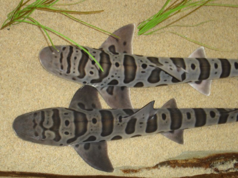
Leopard sharks - so pretty! Source


The lunch destination was "Limantour Spit," which is the narrow strip of beach that almost cuts the estero off from the greater Drakes Bay (a wide bay on the Pacific Ocean, just south of Point Reyes). The Spit was covered in white Pelicans:


Taking a lunch break on the sand bar at the mouth of the estero.

Big group of BASK paddlers at the launch site.
According to this writeup by the USGS, the unique shape of Point Reyes, which extends approximately 15 km out from the coast, often made it too difficult for ships to sail far enough west to get around the point. Ships often ended up shipwrecked and stranded in Drakes Bay.

Before the 120 meters of sea level rise that occurred over the last 18,000 years (woah), Drakes Estero was just a river valley, which is why it has such a unique shape. It's sometimes said that it looks like a hand, with Limantour Estero to the east as the thumb (see map below). Today the freshwater inflows from the minor creeks are very small compared to the tides and currents flushing the Estero twice-daily.

The sand barrier (Limantour Spit) that builds up in front of the Esteros is created because the prevailing sediment transport moves from south to north along the coast. Since most of the waves reaching California come from the Pacific Northwest, the waves bend around Point Reyes and end up reaching the beach from the south (kind of counter-intuitive), eroding the sandy cliffs from the south end of Drakes bay. The waves push the eroded sand up along Drakes Bay, where it ends up on the beach.

Phew, ok enough nerding out... 


Date: Sunday, October 7, 2012
Time: 4 hours
Distance: ~9 miles

Fighting the Tide at Elkhorn Slough, Monterey Bay

[blog post interrupted by random clippings from Marika's trip summary!]

In June. Marika, Julia, Whitney, and I decided to go for a paddle in Elkhorn Slough. This was shortly after I found out my company was applying to work on a restoration project for the slough. In 1947 a harbor was built at the mouth of the slough to provide a safe haven for boats coming in and out of the slough. Unfortunately, constructing a permanent structure like a harbor limits the slough's ability to naturally manage itself by opening, closing, and moving north to south, depending on factors like inflows and sediment supply. Since 1947 the slough has experienced massive erosion - even when we were there we could see big chunks of the marsh falling into the channel. Keeping the mouth of the slough wide open makes it so that the water moves in and out with the tide more quickly than it otherwise would. This makes sand and mud move back and forth more quickly. On the ocean side of the slough is a huge submarine canyon: 

Source: NOAA National Marine Sanctuaries
This canyon is like a big sink - much of the sediment that comes out of Elkhorn Slough falls into the canyon and doesn't come back. I found out recently that my company will be working on the restoration project (that I'll be helping to manage!), which will look at different options to try to fix this problem. Getting rid of the harbor isn't really an option, so the main focus will be on importing sediment from other sources (to be determined) and placing it upstream in the slough to try and counteract erosion. The project is just starting, so more info on that later! 

Guy-with-cool-moustache telling us the rules. He later showed us pictures of a baby otter that had jumped into his kayak... There were some very cute kayakers working at this shop... "Also, the cute kayak shop guy lent us his watch because we forgot ours. He was cute I remember that part." - Marika
Pickleweed! One of the main marsh plants native to California. It turns bright red in the fall, so it almost makes it feel like there are seasons here. I tried chewing on it... it tastes like grass, which was a huge relief considering my disagreements with pickles.
Some sea lions chilling out in the marsh. In the background are the cooling towers from the Moss Landing Power Plant, a natural gas-driven electricity generation plant. The plant takes cool water from the slough or ocean and uses it to cool the gas turbines. The warm water gets dumped back in the ocean.

Cormorants and sea lions hanging out on the mud flat.
Happy Julia! Here you can see how quickly the marsh edge is eroding. 

Seagull hanging out above the pickleweed. Everyone in CA hates seagulls because they're invasive, but they're still fun to take pictures of because they're not very scared of people... :)

The slough is full of jelly fish. We tried to pick them up with our paddles and toss them at each, but gravity is not their friend, so they ended up being 2D instead of 3D. It was a little gross, so we stopped. "We passed by a cow farm with manure sliding down a hill into the water...nasty smell." - Marika


While the slough is known for it's excellent sea kayaking, it's also known for intense winds and fast moving tides, that can combine in the afternoons to make for tricky returns to the harbor. The wind was pretty strong on this day, so it took us at least two times longer on the way back to the kayak shop.


Date: Saturday, June 30, 2012
Time: 2 hours
Distance: ~5 miles