You're currently viewing the old version of this site.
Please visit www.nakedkayaker.com for recent posts and better maps, etc.!
Showing posts with label seals. Show all posts

05 April 2014

Moon Snails, Loons, Seals, Sea Stars, and Fish Heads: Tomales Bay Never Disappoints.

Starved of salt water and kayaks longer than 10 ft, Colorado Jeff flew to San Francisco for a weekend of bingeyaking (my second favorite verb, after sponyaking). The bingeyaking was certainly not spontaneous, as we spent two weeks planning our routes and finding ways to squeeze as many miles into one weekend as possible.

Friday evening logistical madness (read this in fast-forward):
(1) Nena picks up foam blocks at undisclosed location in Oakland.
(2) Nena picks up Jeff from train station.
(3) Nena and Jeff visit Doug to deliver unlucky (I had no idea) lava rock from Hawaii and pick up kayaking gear that Doug generously let Jeff borrow for the weekend. 
(4) Doug gives Nena and Jeff final clue in the pre-kayak-logistics-scavenger-hunt: address of missing sea kayak.
(5) Nena and Jeff drive across Oakland to sketchily retrieve Orange Crush at other undisclosed location.
(6) Nena and Jeff purchase fruits and veggies for the whole weekend. 
(7) Nena and Jeff have a quick dinner at purple-noodle-place (I can't remember the name) and soon return to the Glen House for a brief night's sleep.
(8) Nena wakes up and makes homemade hummus. (Or did that happen at night? it's a blur)

Jeff and I packing up the car in rainy Berkeley on Saturday morning.
Okay that's enough of the 3rd person. We had planned to paddle Estero Americano (i.e. Americano Creek) from Valley Ford Road to its confluence at Bodega Bay. Unfortunately, the weather forecast was looking pprreeettyyy miserable for Saturday, with heavy rains guaranteeing that the mouth of the creek would be open (flowing directly into the ocean instead of ponding behind the beach). The tides and creek current would both be against us on the 6-mile return trip, and we worried we might never return. We reassessed on Saturday morning and ended up a bit further south, on Tomales Bay. 

Nick's Cove. Photo taken from the launch dock. $5 Parking

We arrived at Nick's Cove around 11am on Saturday morning (a leisurely start, to let the rain pass by). While it wasn't raining, the sky was grey and we had the launch site completely to ourselves. Nick's Cove is a remote little tourist destination with a restaurant serving locally-caught fish and cottages right on the water. The whole places is owned by one person, but the boat launch is public.  I've paddled on Tomales a couple times, but always starting from points much further south, so I was excited to check out the north end of the Bay. We paid $5 for parking, launched from the well-kept dock, and headed north. We hugged the east shore and explored the little bays and inlets as we made our way towards the mouth of Tomales Bay. Along the way we found some treasures, like this massive, perfectly-severed fish head. 10 points for the person who can tell me what kind of fish this is!

Monster fish head on the beach. No eyeballs left.
As we rounded Tom's Point, we encountered some beautiful windswept sand dunes. We spent a while between Tom's Point and Sand Point to take pictures of dunes and loons and seals and tule elk (er... cows):

Fuzzy sand dune

Huge sand dunes near Lawson's Landing

A loon! We were surprised to see one in the salt water.
Seals glaring.
Jeff saying "Hi Seals! Happy you're not sharks!"
Nena saying "Hi Cows! Sad you're not Tule Elk!"
We finally peeled ourselves away from the mammals and birds and paddled up to Sand Point, which marks one of the narrowest parts of Tomales Bay. The tide was going out rapidly, and we found ourselves riding the tide towards the mouth of the Bay (and the Pacific Ocean). Ocean waves propagate into the Bay, and with the ebbing tide this made for some tumultuous conditions. The tide was trying to escape and the waves were trying to enter, leaving churning/confused standing waves. We were later informed that this is prime breeding ground for great white sharks. Jeff went and played in the waves while I swiftly crossed the bay and searched for a lunch spot.

Jeff playing in the standing waves at the mouth of Tomales Bay
We realized the tide was ebbing at the same speed we were paddling, so after ~20 minutes of a kayak treadmill workout we decided to pull over for lunch and wait for the current to slow. While snacking on hummus, pita, cucumber, tomatoes, carrots, and fruit, we watched fisherman zip back and forth in little motorboats, emptying traps filled with massive crabs and other critters. Eventually, we returned to the tide treadmill and made it to a wider part of the bay, where the currents slowed. Here we took a few minutes to star gaze:

Red star fish! We also saw sea urchins and anemones.
We stopped briefly to look at these marvelous white cliffs, which offer many caves for exploring during low tide.


Jeff in cave
We stopped at Hog Island (also described in this awesome trip) in the middle of the Bay. One side of the island was carpeted with sea lions, so we gave them some space and instead found some MASSIVE snails, also known as Moon Snails. These snails are predatory, attacking most other shelled mollusks, including fellow moon snails! They envelope their prey and then bore through the shell, sucking out the insides. If I had known this before, I probably would not have put it on Big Purple... This one glommed right onto my boat:

Moon snail!
When we returned to Nick's Cove, we walked to a little shack at the end of the wharf. Smoke curled out of the chimney from a wood stove inside. The shack was humble (I guess most are...), with one large wooden table and some nautical decorations. The phone on the wall is used to order take-out from the restaurant onshore. I'll be back!


Date: April 29, 2014
Time: ~4.5 hours?
Distance: 11 miles

05 November 2012

Drakes Estero, Point Reyes National Seashore

Estero: "small river," "marsh," or "estuary" in Spanish. I looked it up before agreeing to go on the trip. "Drakes" because it's the likely landing spot of Sir Francis Drake in 1579 during his circumnavigation of the world (thank you, wikipedia).

Drakes Bay Oyster Company
We departed from the Drakes Bay Oyster Company around 10am. The Oyster Company manages a pretty extensive network of wooden racks with oyster beds throughout the Estero - when the tide reached a certain water level, we kept scraping the bottoms of our boats on wooden poles just below the surface. There's a lot of controversy surrounding the company -- oyster collection disturbs seal pups, covers eelgrass beds, and leaves some plastic waste floating around the estuary.

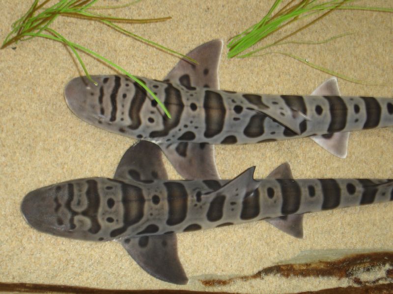
On the way out towards the ocean we turned left into Home Bay, where we discovered a number of bat rays, leopard sharks, jellyfish, and harbor seals. It was my first time seeing a shark from my kayak. Apparently they're harmless to humans, which makes this slightly less exciting. They eat clams, shrimp, worms, and other non-human things. They're native to the west coast (from Mexico to Oregon), and can usually be found in pretty shallow water. Here's what they looked like from my viewpoint:

Leopard sharks - so pretty! Source


The lunch destination was "Limantour Spit," which is the narrow strip of beach that almost cuts the estero off from the greater Drakes Bay (a wide bay on the Pacific Ocean, just south of Point Reyes). The Spit was covered in white Pelicans:


Taking a lunch break on the sand bar at the mouth of the estero.

Big group of BASK paddlers at the launch site.
According to this writeup by the USGS, the unique shape of Point Reyes, which extends approximately 15 km out from the coast, often made it too difficult for ships to sail far enough west to get around the point. Ships often ended up shipwrecked and stranded in Drakes Bay.

Before the 120 meters of sea level rise that occurred over the last 18,000 years (woah), Drakes Estero was just a river valley, which is why it has such a unique shape. It's sometimes said that it looks like a hand, with Limantour Estero to the east as the thumb (see map below). Today the freshwater inflows from the minor creeks are very small compared to the tides and currents flushing the Estero twice-daily.

The sand barrier (Limantour Spit) that builds up in front of the Esteros is created because the prevailing sediment transport moves from south to north along the coast. Since most of the waves reaching California come from the Pacific Northwest, the waves bend around Point Reyes and end up reaching the beach from the south (kind of counter-intuitive), eroding the sandy cliffs from the south end of Drakes bay. The waves push the eroded sand up along Drakes Bay, where it ends up on the beach.

Phew, ok enough nerding out... 


Date: Sunday, October 7, 2012
Time: 4 hours
Distance: ~9 miles

20 July 2010

Seal Cove and around Bartlett Island (Mt. Desert Island Day #3)

Here is part 3 of 3 (Yes, the days are out of order, but I guess that's just going to be a trend in this blog), a guest post by Mary Kate Wheeler summarizing our third and final paddle on Mt. Desert Island in Maine. 

After a last minute decision to join Nena and Ben's MDI Expedition, I headed east from Warren, Vermont on Friday, arriving at the campsite just minutes after dinner ended. Fortunately my ever prepared companions dug up some leftovers and even an extra tent to make me feel well at home.

 Fisherman dinghies at the put-in.

Mist hovered along the coastline as we drove to our launching point on Saturday morning. After hearing a rumor of exceptionally friendly marine life off the western side of the island we chose to paddle out of Seal Cove. Although it seemed to be a popular spot for fishermen and motor boats, the cove provided a nicely sheltered place to launch kayaks.

 
 At the put-in, with Mary-Kate's self-made skin-on-frame kayak in the background.

Our goal of having close and personal encounters with marine mammals was quickly and unexpectedly met. Paddling among lobster buoys on our way out of the cove we spotted dark dorsal fins of several porpoise (at least we think they were porpoise – probably harbor porpoise) swimming in our general direction. We paddled towards the pod and waited, scanning the surface, until a pair came up almost underneath Nena's boat. Not too interested in paddlers, the porpoise continued on their course and we observed for a while before continuing on ours.


After leaving Seal Cove we turned north and paddled along the western shore of MDI, passing Hardwood Island to our west. We continued north past Folly Island and Pretty Marsh Harbor. By the time we entered Bartlett Narrows - the waterway separating Bartlett Island from the main island - the flood tide had created a strong current that carried us quickly to the northern end of Bartlett Island.

Knowing that we would be paddling against wind and current on our return trip, we still chose to paddle around the northern point of Bartlett Island and return on its more exposed western side. Although the paddling became more difficult our work paid off as we saw two harbor seal - one on the northern side of the island, and a second one near the island's southern point. 

 Mary Kate and Ben paddling next to Bartlett Island.

About half way down Bartlett Island we stopped for lunch at a gravely beach with a beautiful view of Blue Hill Bay. We timed our rest so we would be off the water while the flood tide current was at its peak. Still, the final part of our trip was a good challenging paddle, with wind, current, and some small but exciting waves off the island's points

We made one crossing, from the south point of Bartlett Island back to the western shore of MDI, and then retraced our path from the morning. On the way back into Seal Cove we sighted guillemots, small diving birds with amazingly red feet, close relatives of the puffin.

Date: July 18th, 2010
Distance: 17.6 miles

Our long day of paddling along the incredible Maine coastline was completely satisfying. Yet we somehow managed to fit in more adventures that evening, climbing the highest peak on the Atlantic Coast, Cadillac Mountain (by car) before indulging in a fresh seafood dinner at Head of the Harbor restaurant in Southwest Harbor. 


Not bad for a summer Saturday in Maine.

- Mary Kate