Today marks the start of a 24-day cross-country road trip from San Francisco to Boston. I'll be heading up the west coast through Corvallis, Portland, Seattle, and the San Juan Islands before taking a turn and heading east through Bozeman, Bismarck, the Great Lakes, Rochester, NYC, and finally Boston. My hope is to post every couple days, which means my writing will be much more stream-of-consciousness. Apologies in advance for the typos and lack of research. I'm excited to share my experiences as they happen!
A quick recap: In March I found out I'd been awarded a Fulbright grant to study flood management in the Netherlands at the Technical University of Delft (TUDelft). I spent a few weeks hemming-and-hawing about whether or not to leave my great job as a coastal engineer in San Francisco and how to relay the news to my company. In April I broke the news, and the outcome was positive! They offered to let me continue working part time remotely during my year away.
Fast forward: much packing and selling and spreadsheeting later (I'll have to post my planning spreadsheet template at some point), I'm sitting in the Bed Bath and Beyond parking lot in Larkspur waiting for Alice to begin the first leg of this next adventure. Tonight we'll be staying at MacKerricher State Park on the coast in Mendocino County. We'll be kayaking on one of the nearby rivers today - location still to be determined.
The past couple weeks have been incredible. While saying goodbye every day is sad, it's been great to spend time with the amazing California friends I've gotten to know over the past 3 years. I'm already looking forward to my return to the west coast :)
Hello Tennessee Valley, you beautiful dramatic landscape!
For 4th of July Alice and I decided to visit her favorite spot in Marin: Tennessee Valley. The hike takes you 1.8 miles from a parking lot through the lush valley to an open coast beach. Tennessee Cove lies between Muir Beach and Rodeo Beach - both of which we visited last year on a coastal paddle. Dark sand covers the narrow, steep beach at the end of the trail. Alice dodged crashing waves to run around a point and explore another narrow beach on the other side. Ten minutes later I began to wonder whether it was time to send out a rescue team, but she soon sprinted back around the point.
Our busy itinerary didn't allow for much beach lounging, so we hiked back and drove to Alice's adorable apartment in Mill Valley. After much putzing around, mushroom marinating, and the usual discussions, we got our butts in gear and loaded Alice's boat on my car. Our mutual boredom with launching from Seatrek in Sausalito led us to scoping out a more stealthy launch site. After a couple unsuccessful launch-searching-adventures, we found a perfect launch site at the mouth of Coyote Creek in Richardson Bay. The only catch: we had to park in the Holiday Inn Express parking lot, which was built in the middle of the marsh in 1972 and will very soon be under water thanks to sea level rise. We stealthily and speedily unloaded the boats and launched from a tiny little rocky beach next to the walkway over Coyote Creek. The time was 7:15pm.
With 1 hour of sunshine remaining, we kept the paddle short and sweet. We headed south under the 101 bridge, visited the seals, and peered into some floating boat houses. A river of fog poured gently over the Marin Headlands, disappearing on its way down the hill.
On the way back, Big Purple and White Lightning posted for a photo shoot. These boats are going to miss each other! Luckily they'll have one last float together in the Mendocino sea caves in a couple weeks!
When we returned to the Holiday Inn, we were relieved to see Tess (my blue subaru) still parked and ticketless. I leave you with a portrait of Big Purple and a silhouette of Mount Tam:
Date: July 4th, 2014 Distance: ~4.5 miles Time: ~1.5 hrs?
I should really start being more precise with these distances/times... the time is always a complete guess, and in this case so is the distance because our destination was a red sailboat, which google maps does not capture...
A couple weeks ago a patchwork group of us spent a night camping out on Tomales Bay. Last year's trip was super fun and we wanted to recreate it. This year we started on the west side of the Bay, near Inverness, and paddled north until we found a beach that was sufficiently wide for camping. For the rest, I'm going to be lame for this trip and refer you to Rob's blog post (click the Journal tab), which awesomely and succinctly describes this year's fun. He also has all my photos, so go look there! :) Dates: June 21st and 22nd Distance: ~8.5 miles Time: 2 days!
The perfect kayaking trip should start something like this: a cool foggy morning, bundled in your favorite sweatshirt, with 30 minutes of meditative/caffeinated (do those cancel each other out?) beach sitting: bare toes hidden inside the boat for warmth.
Jackie (trip initiator), Doug, Liz, and Carrie arrived around 9am. Text from Alice, 9:10am: "I just woke up!" The rest of us launched off the sea-weedy low-tide beach around 10am.
The fog brings out the green.
The paddle south was reasonably calm, with the exception of Hurricane Gulch (so named because of its gusty tendencies). We paddled past the usual fleet of massive yachts at the Pelican and Sausalito Yacht Harbors investigated a couple fire boats. A large Buddha statue stood proudly at the helm of the freshly painted fire boat.
Visiting a decrepit and a newly renovated fire boat.
We tucked into shore and soon arrived at the Sausalito-Marin City Municipal Wastewater Treatment Plant. Based on this newsletter, the plant underwent an odor-reduction revamp in 2007, but our noses told us a different story!
Doug chilling in the eddy near the wastewater treatment plant.
Sea Glass Beach was just around the corner from the wastewater treatment plant. We dragged our boats up onto the beach and began an epic 1.5 hour picnic. Doug kindly offered me his pistachios and stale tortilla chips, which I devoured with gusto (I'd left my thai green curry in Tess's trunk). We discussed many important topics, such as the side of everyone's "Buttons." We determined that Liz's buttons are hidden but large, and Doug's buttons are numerous. Jackie gave me some great suggestions about visiting the San Juan Islands (one of my upcoming road trip destinations). Doug found a new way to use his kayak as a reclined chair. Liz and I discussed TV shows, for which Jackie judged us harshly. Jackie tells an epic story about a sketchy cat-Man who likes to hover outside her patio door. It went on... and then Alice arrived!
Alice finally arrives at Sea Glass Beach!
Foggy view of San Francisco from Sea Glass Beach
The return trip was uneventful and speedy. Alice and I quickly loaded our boats while the others rinsed and put away their borrowed ETC kayaks. Alice tried to recruit a fellow french-fry-eater, with no luck. After a quick goodbye I was off to try my hand at mountain biking with Bailey up at China Camp!
Date: Sunday, June 1st, 2014
Distance: ~ 5 miles
Time: ~4 hours (including a leisurely 1.5 hours on the beach!)
Let me introduce you to Alice, my wonderful Bay Area kayaking buddy. She wrote this guest post about our quick trip up to Lewiston Lake over Memorial Day weekend. We also paddled on Whiskeytown Lake, which you can read about here. The last time we paddled on freshwater was at Clear Lake in June 2013, so this was quite refreshing!
After dilly dallying waterside at the Berkeley Marina (Nena
had just completed a heroic game of kayak water polo and we were watching the
more advanced paddlers warm up), Nena and I left the Bay’s sparkling waters for the heat of mid CA. At first it didn’t feel like it made sense
to leave such pleasant weather behind because the Bay was so glorious, but it
was cool to travel through so many climate zones- arid, agricultural, mountains
and valleys. My camping book guided us just north of Whiskeytown Lake to
Lewiston Lake, where we nabbed the final walk-in site at the end
of the loop, hugging the southwestern side of the lake.
Lewiston Lake view, facing south, from a short hike we did before our paddle.
We were struck by the beauty and calm of Lewiston Lake and were pretty pumped to get on some fresh water, but after a 4+ hour car ride, we opted to stretch our legs first and kayak around part of the lake’s 15 miles of shoreline. We saw some amazing blue flowers and some cool butterflies. Apparently blackberry bushes line the lake, but we were a little early for those.
Eager to paddle before sunset, we unloaded our boats and launched into the water from the parking lot's rocky slope. The wind seemed to pick up just as we set out on our mini paddle. We hugged
the shore, heading towards the dam that separates Trinity and Lewiston Lakes. Nena
was in heaven to be on a lake and I was too; so much that I lost my Native
sunglasses while reenacting a whitewater event. I leaned back, hit my back deck, and felt my glasses bounce off my head. They spiraled slowly down into
the lake’s depths. We accepted their fate, and continued on, noticing fish
jumping and pretty wildflowers growing off of the rock slopes.
Alice, with sunglasses
Lewiston Lake felt more like a fishing
destination than a paddling one, but it wasbeautiful, and with a motor craft speed limit of10 mph, it was pretty
peaceful.As we paddled by a Marina, the lake turned into more of a riverine environment, and we noticed some marsh mazes and cool tufts of
grass sprouting up intermittently - a scene from The Lorax. We took shelter from the wind in the grasses, and headed into
the more lake-like area along the other side of the reservoir and behind a tall hill slope that jutted out and cast a shadow from the wind. The return was wearisome, as
the wind continued, but we invented strategies to pull through it, such as
closing ones eyes while paddling (surprisingly fun), paddling backwards, and
singing.
These grassy tufts reminded me of the Lorax and Nena of Wilson, the volleyball
Beaver dam!
We made it back before dark, but considerations of practicing
rolling or swimming were dashed as the temperature dropped and our stomachs grumbled. We decided to forego a campfire, ate dinner in the (scenic) parking
lot, and surrendered to quiet/sleepy time. I ventured out of my tent
in hopes of glancing a few straggling shooting stars from the meteor shower the night
before. Instead, I dozed off while watching the gorgeous sky full of stars through my tent fly, no meteors in sight… All in all, a pretty relaxing spot, a great
paddle, and good camping that all lead up to the larger lake that followed: Whiskeytown!
Date: Sunday, May 25th Distance: ~ 6 miles Time: 2 hrs?
Last weekend Alice and I made an expedited road trip up towards Redding to dip our paddles in freshwater for a change. She'll be writing a post about our first day of paddling on Lewiston Lake, so stay tuned (Alice is a teacher and tomorrow is her last day of school!). Around 6:45am on Memorial Day we departed our lovely hill-side campsite at Lewiston Lake and headed back towards Whiskeytown Lake, stopping only for coffee/CheezIts/Ritz crackers at a gas station (surprisingly open at 7am on a holiday). Alice humored me as I cranked up the Whiskeytown (a country band that I discovered during my Friday Night Lights phase, and the real reason I wanted to go on this paddle). We launched from a little scarp adjacent to Oak Bottom Marina around 8:30am and began a relaxing morning paddle.
Launching at Oak Bottom Marina
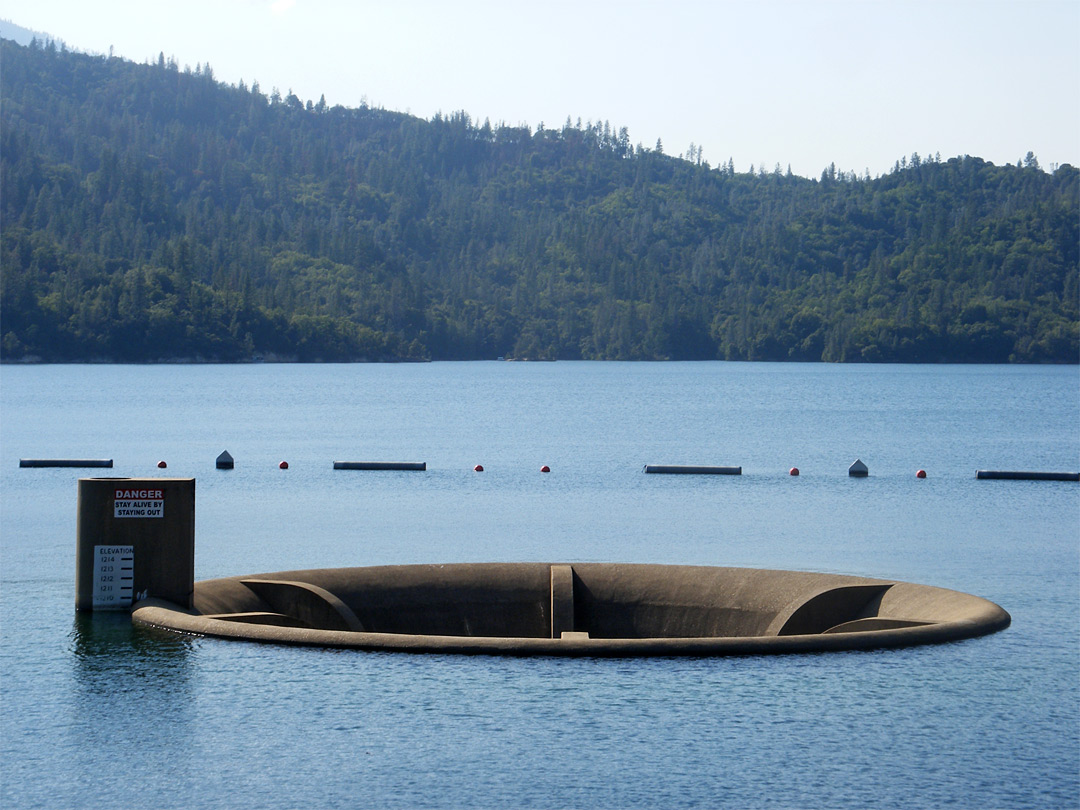
We tried to find Oak Bottom Ditch Trail (the long narrow channel extending from the NW corner of the lake -- see map below), but we must have overshot and ended up in one of the gullies just south of it. It's hard to find your way on these lakes, where everything looks similar and depth is hard to perceive. We continued along the west shore until we arrived at Brandy Creek, a picnic area/trailhead/recreational area where you can rent kayaks or hang out on a sandy beach. Alice landed on shore to enjoy some time on the beach. I carried on for another 45 minutes, determined to get a glimpse of the Clair A. Hill Whiskeytown Dam at the south end of the lake. I also identified an intriguing (but poorly named) feature on the map called the "Glory Hole," which was adjacent to the dam. I told Alice that I planned to investigate. Unfortunately I only had time to turn a corner and view the dam from afar, no glory hole in sight.
Gorgeous spring morning
Alice rounding the bend.
Upon returning to Brandy Creek, Alice informed me that she was very relieved to see me after having read some pamphlets about the lake and finding out what the glory hole was. Read on...
Tree on a rock!
A little history & hydrology... Clear Creek was dammed in 1963 by the Bureau of Reclamation to create Whiskeytown Lake for flood management, water supply for irrigation, and electricity generation. The dam is earthen, which means that it should never be overtopped by water (or it can fail catastrophically). To prevent overtopping of the dam during big storms, the engineers had to include a way for water to drain from the reservoir at a high rate. In a previous post I talked about an emergency spillway adjacent to an earthen dam on Virgil Creek in NY. In the case of Whiskeytown Lake, the spillway is a "Glory Hole" spillway (poorly named), which is essentially a tall drain that water can flow into once the reservoir gets too high. According to this website, the spillway could drain an olympic sized pool in 4 seconds.
Normal conditions
Overflow conditions
I'm happy to tell you that Big Purple and I did not get sucked into the glory hole, and I will never attempt to approach one again. Luckily the lake was not at flood stage, so the spillway looked more like the top picture!
[This post has been in draft form for 1.5 months, so I figured it was time to accept its imperfections and wrap it up. Lindsey, my fellow king-tide tour-guide also wrote a post, available here]
Choose inundation over inebriation** and celebrate King Tides because it's much more exciting than celebrating the New Year. Why? [Thanks to Lindsey for helping brainstorm this list]
The party don't stop: They happen for 3 days, so you can "Cheers!" and wish everyone a HAPPY KING TIDE at least 3 times. And since they happen in different places at different times, you can chase the tide and have that exciting moment multiple times in a day.
The party don't stop #2: Another good reason to drink at the Embarcadero
Play; Splashing in puddles an getting hit by waves in normally dry places.
Excitement: Fleeing men in golf carts
See the future: See what the world will look like every day with sea level rise.
And, because this is a kayaking blog... Expanded kayaking territory. As the water rises, it moves into nearby low-lying areas that are not normally wet, creating new spaces for kayakers to explore.
** A wonderful expression coined by James Jackson What are King Tides?
King Tides are the most extreme astronomical* tides that occur every year. A couple times per year, the earth, moon, and sun align in a way that creates the largest tide range. These days it's common for people to compare King Tides to sea level rise. The high tides that we see during the 2013 King Tides will likely happen on a daily basis in ~50 years (and the future King Tides would be even higher!). This year I decided to visit the coast during the King Tides so I could get a sense of what sea level rise might look like (on a good day, without storms).
* Sometimes non-astronomical forces, like weather/waves/storm, can raise tide levels for short periods of time. These changes are less predictable, while King Tides are regular and predictable.
Lindsey, Doug, James, and Barry were my tide-buddies for this year's celebration.
King Tides at the San Francisco Embarcadero (12/31/2013)
On the morning of New Years Eve Lindsey and I snuck out of the office and walked a half mile to the Embarcadero waterfront in San Francisco. The king tide was scheduled for 9:48 am (a 7.07 foot tide). We went to Pier 14, between the Ferry Building and the Bay Bridge, where the King Tides have flooded the Embarcadero in the past. Here are some photos:
Stairwell flooded, and waves breaking onto the sidewalk.
A video of waves lapping over the Embarcadero:
We (Lindsey, Barry, and I) also returned later at the very lowest tide of the day (during King Tides, the lowest tides get very low, so it's a great time to go tide-pooling!). We ran into one of Barry's friends who promptly offered me and Lindsey a ride on his bike-taxi to the Embarcadero. We celebrated the low tide with a six pack of beers, and cheers-ed! at 4:42 pm, when the tide hit -1.35 feet. Here's one of many low-high comparison photos we took:
Extreme low tide:
Extreme high tide:
And the view of San Francisco at sunset wasn't so bad either:
King Tides at Beach Boulevard in Pacifica, CA (1/1/2014)
The next day, Lindsey and I picked up James and Doug for our first King Tide tour of 2014. Our first stop was Beach Boulevard, CA. We also decided to form a band called the King Tide Kids. Cover album:
The crew: James, Doug, Lindsey, and Nena
No beach at high tide, with waves crashing on the massive revetment
We watched a group of kids standing at the edge of the railing daring each other to stay when big waves crashed over the seawall.
Big waves rolling under the Beach Boulevard Pier
King Tides in Redwood City (1/1/2014)
Our final stops were in Redwood City, where we discovered a dock completely bent out of shape by the extreme high tide:
We (ok, I) decided to jump this fence to get a better view of the Bay at the end of the levee. Minutes later a small golf cart came bumbling along, catching up with us when we finally reached the view point. Two very angry men questioned us: "What was going through your mind when you walked past the 'No Trespassing' sign?" Thankfully Lindsey and Doug fielded the questions while I carefully avoided eye contact.
Alice, Stijn, Johnny, and I met at the Berkeley Marina at 9am for a very "unplanned/casual" paddle. I use quotes because it took us a week of rapid-fire emails and changing plans to reach this point. Most of us (except Johnny) had abandoned our boats for far too long. For most of us, this was our first sea kayaking trip out of Berkeley. We launched from the docks near Cal Adventures on the south side of the marina. The parking is free and the launch works well at most tide levels.
Johnny and Alice packing up boats.
We headed north, swinging wide and staying pretty far offshore. We had no destination, but eventually headed towards Brooks Island (previously Isla de Carmen, Rocky Island, Bird Island, and Sheep Island!). The island has a long history - first settled by the Ohlone Indians, later used for grazing/oyster harvesting/quarrying, and finally acquired by the East Bay Regional Park District in 1968 and converted to a preserve. Today it is a bird sanctuary - no landing allowed.
Johnny, Alice, and I at Bird Rock. Photo by Stijn Schiffeleers.
Shameless selfie, included because that's Brooks Island in the background.
Hazy San Francisco in the background, cormorants in the front. Photo by Stijn Schiffeleers.
The paddle was casual to say the least. We thought we could paddle around the Island but realized a long breakwater nearly doubled the length of paddling (see map below). Another reason why planning can sometimes be a good idea. Alice, always the rebel (and having drank too much water), did a bit of island exploring by foot. On the way back the wind picked up a bit, and we were joined by a number of sailboats near the marina. Stijn and I bonded over our mutual love for the Belgian band K3. The Berkeley Pier looks much cooler from below: the piers extending infinitely in both directions like a room of mirrors.
Stijn hiding behind a pile at the Berkeley Pier.
Date: Sunday February 23rd, 2014 Time: ~ hours Distance: ~ 10.5 miles
Upon returning to shore we shared a bottle of Wyder's Pear Cider and caravanned to the nearest mexican restaurant where we were shocked by the monstrous portions and promptly found ourselves in a food coma. Up next, the Cal100! I think we have a lot more training to go...
Alice and the monster burrito we should have shared....

.JPG)
.JPG)


.jpg)