You're currently viewing the old version of this site.
Please visit www.nakedkayaker.com for recent posts and better maps, etc.!
Showing posts with label reservoir. Show all posts

30 May 2014

A Sober Day on Whiskeytown Lake

Last weekend Alice and I made an expedited road trip up towards Redding to dip our paddles in freshwater for a change. She'll be writing a post about our first day of paddling on Lewiston Lake, so stay tuned (Alice is a teacher and tomorrow is her last day of school!). Around 6:45am on Memorial Day we departed our lovely hill-side campsite at Lewiston Lake and headed back towards Whiskeytown Lake, stopping only for coffee/CheezIts/Ritz crackers at a gas station (surprisingly open at 7am on a holiday). Alice humored me as I cranked up the Whiskeytown (a country band that I discovered during my Friday Night Lights phase, and the real reason I wanted to go on this paddle). We launched from a little scarp adjacent to Oak Bottom Marina around 8:30am and began a relaxing morning paddle.

Launching at Oak Bottom Marina
We tried to find Oak Bottom Ditch Trail (the long narrow channel extending from the NW corner of the lake -- see map below), but we must have overshot and ended up in one of the gullies just south of it. It's hard to find your way on these lakes, where everything looks similar and depth is hard to perceive. We continued along the west shore until we arrived at Brandy Creek, a picnic area/trailhead/recreational area where you can rent kayaks or hang out on a sandy beach. Alice landed on shore to enjoy some time on the beach. I carried on for another 45 minutes, determined to get a glimpse of the Clair A. Hill Whiskeytown Dam at the south end of the lake. I also identified an intriguing (but poorly named) feature on the map called the "Glory Hole," which was adjacent to the dam. I told Alice that I planned to investigate. Unfortunately I only had time to turn a corner and view the dam from afar, no glory hole in sight.

Gorgeous spring morning
Alice rounding the bend.
Upon returning to Brandy Creek, Alice informed me that she was very relieved to see me after having read some pamphlets about the lake and finding out what the glory hole was. Read on...

Tree on a rock!
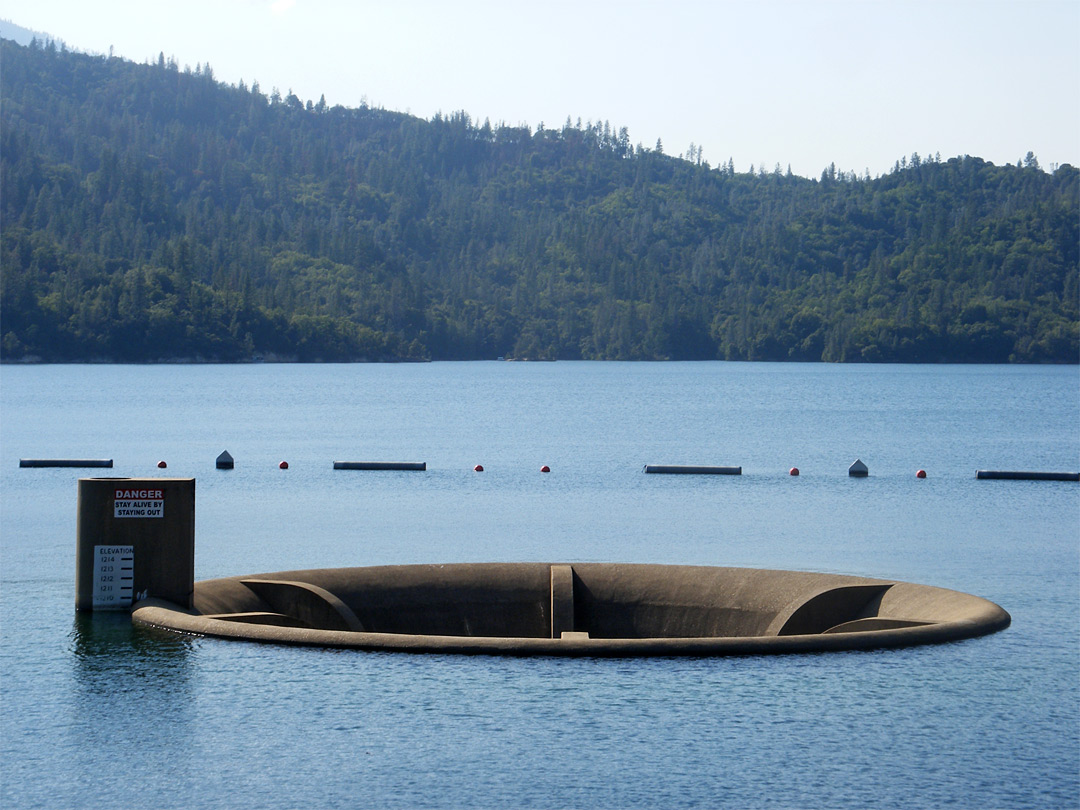
A little history & hydrology... Clear Creek was dammed in 1963 by the Bureau of Reclamation to create Whiskeytown Lake for flood management, water supply for irrigation, and electricity generation. The dam is earthen, which means that it should never be overtopped by water (or it can fail catastrophically). To prevent overtopping of the dam during big storms, the engineers had to include a way for water to drain from the reservoir at a high rate. In a previous post I talked about an emergency spillway adjacent to an earthen dam on Virgil Creek in NY. In the case of Whiskeytown Lake, the spillway is a "Glory Hole" spillway (poorly named), which is essentially a tall drain that water can flow into once the reservoir gets too high. According to this website, the spillway could drain an olympic sized pool in 4 seconds. 

Normal conditions
Overflow conditions
I'm happy to tell you that Big Purple and I did not get sucked into the glory hole, and I will never attempt to approach one again. Luckily the lake was not at flood stage, so the spillway looked more like the top picture!

Date: Monday, May 26th (Memorial Day)
Distance: 8.5 miles
Time: 3 hours

06 May 2012

Refresher paddle on San Pablo Reservoir

Brief vent (Scroll down for a happier discussion):

California Parks like rules, fees, and regulations.

I sometimes think that moving here has made me more conservative (in the fiscal sense). I don't remember paying for park entry, parking, or launching during the summer I paddled on the 11 Finger Lakes. If we encountered someone who told us to pay, we could drive down the next dirt road and find a free spot to put-in. Also, night paddles are not illegal in NY. What I really wanted to do on Saturday was to have a peaceful sunset paddle on the reservoir, but I had to be off the water by 6:30pm (1.5 hours before sunset). 

I do understand why they have these (incredibly complicated) rules and fees. Virtually every freshwater lake within an hour drive is a source of drinking water for the Bay Area. It's important to protect these from any sort of contamination, so adding fees and inspections and prohibiting bodily contact keeps the number of visitors down and ensures that the water stays potable. 

There are just too many people here. 

The tab:
Parking pass: $6.50
Launch fee: $3.50
Boat inspection fee: $6 (I guess if they'd done this in NY we wouldn't have so many zebra mussels... I was able to talk my way out of this by insisting that my boat had not seen water in 8 months)
Total = $16 for a 2 hour paddle (and you can't even practice rolling!)

Happier discussion:
I like to keep my feet dry, so avoiding bodily contact was not really an issue. I spent two hours paddling out to the north end of the reservoir (where the dam is) and back. There were quite a few motor boats and fishermen/kids out enjoying the sunshine. 

The top of the earthen dam at the north end of San Pablo Reservoir

Easy Bay Municipal Utility District owns many of the reservoirs supplying water to the Bay Area. Reservoirs are often connected in series. San Pablo Creek was dammed with an earthen dam to create the reservoir, but it isn't the main contributor of water. The Briones Reservoir and the Pardee Reservoir (in the Sierras) both drain into the San Pablo Reservoir.

I guess they have Blue Herons on the west coast too :)
Fun wikipedia fact: In 2004 the Utility District reported that the dam was at risk of settling 35 feet if a serious earthquake were to hit, so they lowered the water levels and did some retrofitting projects (adding some concrete to the earth) which were completed in 2010. 

Too bad it wasn't lunch time!
From what I could tell (flooded picnic tables) the water levels seem to be back up, if not higher! Maybe this is a precaution since the snowpack is virtually non-existant this year.

Date: Saturday, May 5, 2012
Time: 2 hours 
Distance: ~ 6 miles


30 January 2012

Pinnacles National Monument (a belated first post in California!)

Here we are again, with 8 months since my last post. To be honest, I have at least 5 posts started in my draft box with the best of intentions. I think it stems from my desire to document the details of everything. It's just too overwhelming once you've missed a couple months. Where do you start!? For now I'm letting myself skip the last 8 months. Maybe later I'll be motivated and fill in the (more-exciting-than-my-current-life) gaps, including some more Iceland posts, a few paddling posts, 6 weeks of unforgettable/hilarious/adventurous cross-country road trip posts, and 5 months of exploring my new state of residence (California!). Oh! How could I forget? My new job, which involves a lot of analyzing and a little bit of exploring beaches and rivers!

I'll start small, I guess. Pinnacles National Monument is pretty small (maybe that's why it's called a monument?). It's a national park about an hour southwest of Monterey Bay, in the town of Paicines (which, from what I can tell, consists of an intersection between two small county highways). The drive to the park was lovely! This is assessment likely has more to do with the fact that I was taking my new (used) car on a trip for the first time, the sun was out (68 degrees!), and it was a Sunday morning so the Bay Area traffic was somewhat tame.

Since all the Californians were in Tahoe pretending to ski in puddle of slush, the park was very peaceful. I only encountered a few hikers on my 8 mile loop.

The first part of the trail took me to the Bear Gulch Caves and Reservoir (Californian for murky puddle). The entrance to the cave had a daunting sign that read, "Caution: Flashlights Required." Since this was my first longish solo hike experience, I started having flashbacks of 127 Hours. I took a 3 minute water/digging-for-headlamp break before entering the CAVE. 2 minutes later I was back in bright daylight and feeling rather sheepish. The next few caves were similarly brief, but still fun to squeeze through. Apparently the caves are often closed due to wet conditions and for bat habitat, so I got lucky!

Bear Gulch Caves
At the end of the caves I arrived at a cute little reservoir. I didn't spend too much time there since it's apparently the place for romantic couples to hang out at 11am on a Sunday - awkward. Onwards!

Bear Gulch Reservoir
The next bit was pretty steep and dry. Here I'd like to pause and say that what I really miss about the east coast is the lush-ness of the woods. Even when you're in a forest in the middle of winter in California, it feels like the moisture is being sucked out of you.

This steep trail took me up to the "High Peaks," which are the spikes most commonly documented in photos taken at Pinnacles. These neat geologic formations are thought to be part of the Neenach Volcano, which was split by the San Andreas Fault. The Pacific tectonic plate moved up and took the Pinnacles with it. Since this particular type of rock is very erodible, it led to the visually appealing smooth rock outcroppings that remain today. (Here ends my attempt at knowing anything about geology)


The trail through this section is very narrow and steep (up long staircases cut into the boulders) - it was a lot of fun! Since there aren't really any trees you have a great view from pretty much any angle. I paused here for a delicious lunch featuring the amazing avocado (which is affordable year round!):

The High Peaks (left) in Pinnacles National Monument

On the way down I accidentally missed my turn for the Condor Gulch Trail and ended up adding a few extra miles, but I ended up seeing 3 condors circling above my head for the rest of my hike. Pinnacles is part of the California Condor Recovery Program. On my hike I saw one of the resident ornithologists monitoring the condor populations.

Here are a few more pictures from the hike down:
Manzanita trees have really stark red bark. They're evergreen and drought resistant! And very pretty...
A little bird with a blue back... not sure exactly what kind!
I'd really like to get back there and hike up to the Pinnacles in the evening or early morning, when the sun is at an angle that makes for interesting lighting - I think it would be a spectacular sight! Oh, one more thing I should mention. This park is an excellent place for outdoor rock climbing, so I need to make a point of meeting climbing gear-heads in the Bay Area to take me climbing... if you have any connections let me know! :)