You're currently viewing the old version of this site.
Please visit www.nakedkayaker.com for recent posts and better maps, etc.!

01 June 2014

Lewiston Lake: The Annual Freshwater Paddle

Let me introduce you to Alice, my wonderful Bay Area kayaking buddy. She wrote this guest post about our quick trip up to Lewiston Lake over Memorial Day weekend. We also paddled on Whiskeytown Lake, which you can read about here. The last time we paddled on freshwater was at Clear Lake in June 2013, so this was quite refreshing!

After dilly dallying waterside at the Berkeley Marina (Nena had just completed a heroic game of kayak water polo and we were watching the more advanced paddlers warm up), Nena and I left the Bay’s sparkling waters for the heat of mid CA. At first it didn’t feel like it made sense to leave such pleasant weather behind because the Bay was so glorious, but it was cool to travel through so many climate zones- arid, agricultural, mountains and valleys. My camping book guided us just north of Whiskeytown Lake to Lewiston Lake, where we nabbed the final walk-in site at the end of the loop, hugging the southwestern side of the lake.

Lewiston Lake view, facing south, from a short hike we did before our paddle.
We were struck by the beauty and calm of Lewiston Lake and were pretty pumped to get on some fresh water, but after a 4+ hour car ride, we opted to stretch our legs first and kayak around part of the lake’s 15 miles of shoreline. We saw some amazing blue flowers and some cool butterflies. Apparently blackberry bushes line the lake, but we were a little early for those.


Eager to paddle before sunset, we unloaded our boats and launched into the water from the parking lot's rocky slope. The wind seemed to pick up just as we set out on our mini paddle. We hugged the shore, heading towards the dam that separates Trinity and Lewiston Lakes. Nena was in heaven to be on a lake and I was too; so much that I lost my Native sunglasses while reenacting a whitewater event. I leaned back, hit my back deck, and felt my glasses bounce off my head. They spiraled slowly down into the lake’s depths. We accepted their fate, and continued on, noticing fish jumping and pretty wildflowers growing off of the rock slopes. 

Alice, with sunglasses

Lewiston Lake felt more like a fishing destination than a paddling one, but it was beautiful, and with a motor craft speed limit of10 mph, it was pretty peaceful. As we paddled by a Marina, the lake turned into more of a riverine environment, and we noticed some marsh mazes and cool tufts of grass sprouting up intermittently - a scene from The Lorax. We took shelter from the wind in the grasses, and headed into the more lake-like area along the other side of the reservoir and behind a tall hill slope that jutted out and cast a shadow from the wind. The return was wearisome, as the wind continued, but we invented strategies to pull through it, such as closing ones eyes while paddling (surprisingly fun), paddling backwards, and singing.

These grassy tufts reminded me of the Lorax and Nena of Wilson, the volleyball
Beaver dam!
We made it back before dark, but considerations of practicing rolling or swimming were dashed as the temperature dropped and our stomachs grumbled. We decided to forego a campfire, ate dinner in the (scenic) parking lot, and surrendered to quiet/sleepy time. I ventured out of my tent in hopes of glancing a few straggling shooting stars from the meteor shower the night before. Instead, I dozed off while watching the gorgeous sky full of stars through my tent fly, no meteors in sight… All in all, a pretty relaxing spot, a great paddle, and good camping that all lead up to the larger lake that followed: Whiskeytown!


Date: Sunday, May 25th
Distance: ~ 6 miles
Time: 2 hrs?

30 May 2014

A Sober Day on Whiskeytown Lake

Last weekend Alice and I made an expedited road trip up towards Redding to dip our paddles in freshwater for a change. She'll be writing a post about our first day of paddling on Lewiston Lake, so stay tuned (Alice is a teacher and tomorrow is her last day of school!). Around 6:45am on Memorial Day we departed our lovely hill-side campsite at Lewiston Lake and headed back towards Whiskeytown Lake, stopping only for coffee/CheezIts/Ritz crackers at a gas station (surprisingly open at 7am on a holiday). Alice humored me as I cranked up the Whiskeytown (a country band that I discovered during my Friday Night Lights phase, and the real reason I wanted to go on this paddle). We launched from a little scarp adjacent to Oak Bottom Marina around 8:30am and began a relaxing morning paddle.

Launching at Oak Bottom Marina
We tried to find Oak Bottom Ditch Trail (the long narrow channel extending from the NW corner of the lake -- see map below), but we must have overshot and ended up in one of the gullies just south of it. It's hard to find your way on these lakes, where everything looks similar and depth is hard to perceive. We continued along the west shore until we arrived at Brandy Creek, a picnic area/trailhead/recreational area where you can rent kayaks or hang out on a sandy beach. Alice landed on shore to enjoy some time on the beach. I carried on for another 45 minutes, determined to get a glimpse of the Clair A. Hill Whiskeytown Dam at the south end of the lake. I also identified an intriguing (but poorly named) feature on the map called the "Glory Hole," which was adjacent to the dam. I told Alice that I planned to investigate. Unfortunately I only had time to turn a corner and view the dam from afar, no glory hole in sight.

Gorgeous spring morning
Alice rounding the bend.
Upon returning to Brandy Creek, Alice informed me that she was very relieved to see me after having read some pamphlets about the lake and finding out what the glory hole was. Read on...

Tree on a rock!
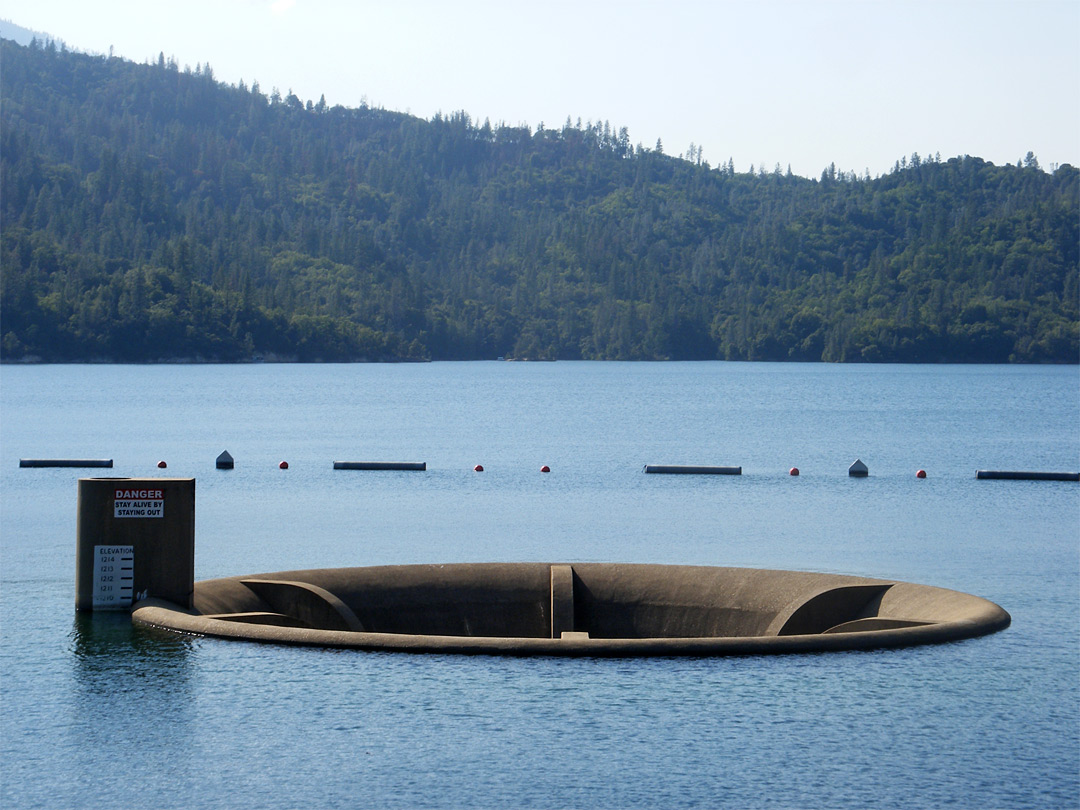
A little history & hydrology... Clear Creek was dammed in 1963 by the Bureau of Reclamation to create Whiskeytown Lake for flood management, water supply for irrigation, and electricity generation. The dam is earthen, which means that it should never be overtopped by water (or it can fail catastrophically). To prevent overtopping of the dam during big storms, the engineers had to include a way for water to drain from the reservoir at a high rate. In a previous post I talked about an emergency spillway adjacent to an earthen dam on Virgil Creek in NY. In the case of Whiskeytown Lake, the spillway is a "Glory Hole" spillway (poorly named), which is essentially a tall drain that water can flow into once the reservoir gets too high. According to this website, the spillway could drain an olympic sized pool in 4 seconds. 

Normal conditions
Overflow conditions
I'm happy to tell you that Big Purple and I did not get sucked into the glory hole, and I will never attempt to approach one again. Luckily the lake was not at flood stage, so the spillway looked more like the top picture!

Date: Monday, May 26th (Memorial Day)
Distance: 8.5 miles
Time: 3 hours

21 May 2014

Out-the-Gate, Finally!

An Out-the-Gate paddle is a right of passage for sea kayakers in the Bay Area. Not just anyone can paddle out under the Golden Gate Bridge and see the unique view of San Francisco from the other side. Intense currents flow through the gate four times a day: twice into the bay (flood) and twice out of the bay (ebb). These tidally-driven currents can be incredibly fast (over 5 mph - 1 or 2 mph faster than a typical sea kayaker), but luckily they can be planned-for well in advance by looking at local tide tables (http://tidesandcurrents.noaa.gov/curr_pred.html). Here's a screenshot from the Bay Area Sea Kayakers' wonderful trip planner website (http://www.bask.org/trip_planner/).


Negative currents correspond to water flowing out the Gate. Alice, Johnny, and I met at Horseshoe Cove (just NE of the GG Bridge) at 2pm to catch the maximum ebb (2.8 kts, 3.3 mph) out the gate. This was my first Out-the-Gate paddle, and I was excited/nervous! Alice and Johnny have done this paddle many times, so I was in good company.

Wind and waves are harder to plan for, as these can only be predicted a few days in advance, and with less accuracy. The forecast called for high winds, and the previous day had been incredibly windy (gusts of 30 mph). William, who was planning to drive down from Redding (4 hours), cancelled because of the forecast. Alice and Johnny, who were both coming from San Francisco, noticed white caps as they drove across the GG Bridge. We made a plan: paddle out to the Gate, regroup, take a look around, and make a decision.

The view from Horseshoe Cove, the launch site.
We paddled by some rock spires (labeled on Google Maps as "Needles Rocks") on our way to the bridge. At Lime Point (does Google make these names up?) we looked left, right, at each other, and said GO! The conditions didn't look too intimidating. We turned a hard right and paddled directly out the Gate. The wind was howling, and the "max ebb" was barely noticeable, but we were able to maintain some momentum.

Approaching the decision point at Lime Point.
Some time later we found ourselves fully out-the-Gate and paddling past Kirby Cove - a common destination for sea kayakers and campers alike. We paused to take some cliche-yet-necessary photos while trying not to lose too much ground, as the waves and wind pushed us back under the bridge. The rare view of San Francisco below the GG Bridge was crisp and dramatic, thanks to incredibly clear conditions. It was fun to imagine the Gate without the Bridge in place -- what the European explorers must have seen when they stumbled upon San Francisco Bay in the 1700s.

This photo makes the wind and waves look small!
We checked in and agreed to continue past Point Diablo. The winds howled around the point, and although we paddled as hard as we could, we often found ourselves in a kayaking-treadmill. Ducking our heads, we pushed on and veered into the first land-able beach. Many years ago, Johnny and his friends dubbed this beach "Poison Oak Beach." It doesn't seem that Google has assigned a name yet, so Johnny's name persists in this post. We sprawled out on the sand like stranded sailors, exhausted from the sprint. Alice befriended a small diapered child who was interested in her boat. We identified 3 nude sunbathers dotting the beach and noticed that the beach was accessible by a rugged trail coming down the hill. Alice, inspired by the nude sunbathers and overwhelming heat/sweat in her wetsuit, stripped down to her bathing suit and basked in the sun.

After 45 minutes of chit-chatting and recovery we launched into the growing surf zone. I launched first with some help from Alice and Johnny. Alice launched next, receiving a smack in the face from a big breaking wave and losing her favorite water bottle in the tizzy. Johnny rescued the water bottle and launched without too much trouble.

Leaving Poison Oak Beach and heading back into San Francisco Bay. Alice on the left, Johnny on the right.
The paddle back was happily uneventful. With the wind and waves at our backs and slack tide approaching, we cruised back under the Gate.

Alice victoriously coasting under the GG Bridge. That's San Francisco underneath the water droplet.
We quickly loaded up our boats and went about our Sunday evening plans. Soreness ensued.


Date: May 11th, 2014
Time: ~3 hours (including long break on the beach)
Distance: 5.5 miles

20 May 2014

Midwest Reunion Road Trip to Morro Bay

In September 2008, Nena and Terry met and moved into a little apartment in Cincinnati, Ohio, where Terry taught Nena how to dance like Justin Timberlake and Nena taught Terry how to recycle (ok, so both of those lessons failed). However, some of the cross-cultural exchanges stuck. For example, Terry developed an affinity for hiking and country music that grew long after the end of the Procter & Gamble internships. In May 2014, Terry visited Nena in California with one request: go on a California adventure.

Commence road trip to Morro Bay, in the first person.

At 6am on Friday morning we departed Berkeley after a much-needed but too-short night of sleep. We beelined down HWYs 880/101/1 until we arrived in exotic Carmel, just in time for a hearty breakfast burrito. We were chatted up by surf-instructor Ed, who nearly convinced us to stick around for surf lessons. After some beach frolicking we continued down scenic HWY 1 along the coast - a stretch of coast that I'm less familiar with. The views were staggering!


We stumbled across some beaches drenched in sea lions, where we gleefully watched them grunt, grown, and throw sand on each other for a half hour.


After some mishaps (1. Nearly running out of gas, then paying $6/gallon, 2. Stopping by Hearst Castle and being severely disappointed - you have to pay $25 just to get near it!) we arrived in Morro Bay, set up camp, went for a short hike to look at the bay, ate a delicious lunch at a vegan/vegetarian restaurant (much to Terry's surprise), and went for a hike in Montana de Oro State Park, just south of Morro Bay.

Views from our hike in Montana de Oro State Park
After surviving the hike without a mountain lion attack, we returned to Morro Bay (the town) and went to the windy beach. We observed a ship practicing turns at the mouth of the harbor for a little while before heading into town for some fish & chips and white wine: classy!

Morro Bay is famous for Morro Rock, which defines the skyline of the Bay (Morro = spanish/portuguese/italian for prominent rock formation). The rock used to be surrounded by water, but was connected to land by the U.S. Army Corps of Engineers to construct Morro Bay Harbor. The rock was quarried for 80 years before being preserved for peregrine falcon habitat. A large power plant, characterized by three tall cooling towers, sits adjacent to the harbor.

Dynegy power plant (a.k.a. "Three Fingers")

We camped out at Morro Bay State Park (only moving campsites once to avoid sleeping next to a Rihanna party and nearly being ticketed the next morning for moving into the wrong campsite). On Saturday morning we arrived at Kayak Horizons just in time for the 10% off deal (arrive before 10 am). I had to launch my boat at Anchor Street Park, a few blocks south. 

5 minute kayak training for Terry
Once Terry was settled into her rental boat, we followed a tip to cross the Bay and look for narrow points in the sand spit, where we could extract ourselves from our boats and hike over the dunes to the ocean-side beach. Apparently we don't know how to follow directions, because we found ourselves in shallower-and-shallower water, eventually bottoming out and having to backtrack. We never did find the trails, but we did get to look at the sand dunes up close.


We meandered down the Bay and then back up towards the harbor to look for seals and otters. Some paddle boarders broke the sad news that otters seemed to be lacking in all their usual hang-out spots, so we begrudgingly accepted that sea lions would be the most exciting discovery:


5 miles later we were tired out and headed back to the rental shop. We departed Morro Bay, refilled on sunshine and salt water, and headed back to San Francisco with a quick stop for delicious Thai food in Paso Robles.

Thanks for visiting, Terry!! :)


Date: Saturday, May 10th, 2014
Time: ~2 hours
Distance: ~5 miles

30 April 2014

Easter Sunday on Estero Americano

At 8:20am on Easter morning, Alice and I simultaneously pulled into our favorite Park-N-Ride in San Rafael. We have a history of perfect timing - we're both 10 minutes early. We loaded White Lightning onto my car (next to Big Purple) and headed up the 101. Estero Americano flows into Bodega Bay, roughly 1.5 hrs from the Bay Area. The launch site is at the end of a dirt road that spurs off the intersection of Marsh Road and Valley Ford Franklin School Road. Another kayaker arrived shortly after us, and spent 20 minutes urging Alice and I to join a kayak racing club in Berkeley.

Parked at the launch site off Marsh Road
Estero Americano is fed by Americano Creek and forms the boundary of Marin County with Sonoma County. The Estero is not always deep enough to paddle - water levels can fluctuate significantly depending on flows in Americano Creek (rainfall), tide levels, and whether or not the lagoon is open or closed at the ocean. We weren't sure whether the lagoon was open, but I've been eyeing this paddle for over a year, so we took a risk and went for it! There is virtually no access by car or visibility from roads during the 6 miles trip between the launch site and the Pacific Ocean - the best way to see it is by kayak/canoe.

The trip begins as little more than a narrow muddy channel winding between flat dairy pastures. Thanks to some recent rain, the fields and hillsides were bright green. Curious cows approached the channel banks to grunt and say hello.

Nena meets cows. Photo by Alice Miller.
Alice checking out Whale's Tail rock
The channel widened after 2 miles amongst the cows. Adjacent hillsides rose, and salt marshes and mudflats replaced the pastures. The last couple miles were by far the most majestic, with steep green hillsides flanking the wide Estero. Alice and I both felt that we had been transported to New Zealand or another more dramatic landscape. A strong wind picked up along this stretch, increasing our sense of isolation as we paddled independently (conversation during windy kayaking quickly leads to sore throats).

And suddenly you're in New Zealand. Photo by Alice Miller.
We rounded the last bend around noon and were welcomed by our own private sandy beach. The mouth of the Estero was open, and the lagoon was still draining (much to our surprise - low tide was at 10am). We dragged our boats up onto the beach and went exploring. Alice walked to the south end of the beach, while I checked out the mouth and basked in the sun. 

Exploring the mouth of Estero Americano. Photo by Alice Miller.
The beach at Estero Americano, facing south
Alice taking pictures of the beach
The return trip passed quickly, and we met a cow carcass along the way. Alice was slightly traumatized, as Easter is supposed to be about rebirth rather than death. I guess that's what happens when you choose kayaking over Easter mass.

Cow carcass


Date: April 20, 2014
Time: ~5 hrs (including 1 hour of sunning on the beach)
Distance: 11 miles

07 April 2014

Keller Beach 'round Point San Pablo to the Chevron Refinery

After our nature-drenched paddle on Saturday, Jeff and I stayed close to Berkeley and checked out the developed shoreline of Richmond in San Francisco Bay. After kayak polo we loaded ourselves + our wet butts into Tess (my blue Subaru) and drove 15 minutes up I-80 to Miller Knox Regional Shoreline. Some of my colleagues are working on a project to restore a pond in the park, so we went for a brief stroll around the pond to take photos. The pond used to be a coastal lagoon/inlet before a railroad was built along the entire shoreline, cutting off connection with the Bay and converting the tidal lagoon to a scummy pond.

After the stroll we parked at Keller Beach, just north of Miller Knox, to launch our boats. A park attendant pulled over in his truck to inform us that we were launching in a very inconvenient location. Rather than take his advice to launch further south, we stubbornly carried our boats down and up the large hill, including multiple flights of stairs. We do this partly for exercise, right?

Keller Beach, the launch site. Warning: you'll have to carry your boat up and down a huge hill if you decide to launch here... 
Armored shoreline railroad running along the front of Miller Knox Regional Shoreline 
We launched from the seaweed-covered beach and paddled north towards the Chevron Pier. In my mileage estimates the night before I assumed that we could paddle through/under the many piers extending from the Richmond shoreline. Alas, Chevron does not allow us to paddle underneath its 48" diameter oil pipeline, so we added a mile (and some stress) to our trip by detouring around the parked oil tankers at the end of the pier.

A barge passing a parked oil tanker. Golden Gate Bridge and Angel Island in the background.
Multiple signs warned us to stay 300 yards away from the pier.

Some machinery at the end of the Chevron Pier. 
Jeff checking out the oil tanker and miscellaneous equipment.
We eventually made it past the pier (which extends ~1 mile into the Bay) and under the Richmond Bridge. Since you can't paddle anywhere in California without seeing seals, we ran into (not literally) some seals propped up on Castro Rocks, underneath the bridge. 

Under the Richmond Bridge. You can't see it here, but we were greeted by a number of ornery seals who were basking on Castro Rocks. To the left of the photo is Red Rock Island, where I paddled a week earlier.
We stuck fairly close to shore on our way north, exploring a number of historic sites along the way, the first of which was this castle between Point Molate and Point Orient:

Point Molate Naval Fuel Depot (decommissioned) 
The castle was originally constructed as part of a winery - the largest winery in the U.S. prior to prohibition. During Prohibition the winery tried to survive on grape juice, but eventually had to shut down, along with a number of other industries along the Point Richmond shoreline. Subsequently, it opened as the Point Molate Naval Fuel Depot in 1941, and later closed in 1998. Point Molate Beach was opened to the public last October (2013) for the first time in 10 years. Currently there are major efforts to convert the castle into a casino, which would be very sad, indeed. Here's a sketch of it back in it's heyday as a winery:

Photo from http://www.pointrichmond.com/pointsanpablo/graphics/

Dilapidated buildings on the west shore of Point San Pablo.
More piers that have collapsed into the bay, leaving behind creosote piles that take ages to degrade.

Apologies for all the kayaking selfies recently. This is the easiest way to deal with having one camera in the group. Also note extensive salt stains on my arm...  
As we rounded Point San Pablo, the main Chevron Oil Refinery came into sight. 

The Chevron Oil Refinery: site of a major fire on August 6th 2012 that sent 15,000 people seeking treatment at local hospitals.
We had lunch nearby on a rebar-filled breakwater protecting a landfill (glamorous). This spot is pretty exposed, so strong winds kept us from a leisurely lunch. Lacking enough vegetables, we finished the hummus with a spoon and were on our way. The afternoon waves tend to pick up in SF Bay, and Sunday was no exception. We paddled hard into the wind until we again rounded Point San Pablo. Across from the Point are two islands (The Brothers), where a lighthouse constructed in 1853 still stands and is also managed as a bed and breakfast.

East Brother Light Station on Brothers Island: Built in 1853, the light house is still maintained and run as a Bed and Breakfast. Reservations start at $315/night!
The return trip was uneventful - I sang bad pop songs to keep up morale (or maybe kill it?). When we rounded the Chevron Pier, the waves had picked up and we tried to surf our way back into shore. We sadly loaded up our boats after the last paddle of our bingeyaking weekend and commenced post-kayaking-logistics-madness, which I won't bore you with but involves a couple hours of driving and washing and drying and showering.


Date: April 30, 2014
Time: ~ 4 hours?
Distance: ~15 miles

06 April 2014

Kayak Polo Uniforms

Last Sunday I brought Jeff with me to Kayak Polo practice at the Berkeley Marina (see this post for an explanation of the sport). Since it was a "rainy" weekend (see photo) everyone else cancelled the night before, and we ended up in a private class with coach Peter. Since there have been exactly zero updates to my kayak polo education/skills, I just wanted to share the ridiculousness/awesomeness of our outfits+gear.

Looooookin' good: